Birr geodata
Birr (Leinster) is a populated place; located in Ireland in Europe/Dublin (GMT+1) time zone. With population of 4,549 people, there are 146 cities with bigger population in this country. Compared to other cities in Ireland, 58.4% of cities are located further ↑North; 61.3% of cities are located further →East and 50.7% of cities have lower elevation than Birr. Note1


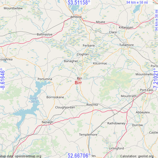
Birr GPS coordinates[2]
53° 5' 29.004" North, 7° 54' 47.988" West
| Map corner | latitude | longitude |
|---|---|---|
| Upper-left | 53.51158°, | -8.61646° |
| Center: | 53.09139°, | -7.91333° |
| Lower-right: | 52.66706°, | -7.21021° |
| Map W x H: | 93.9×93.9 km | = 58.3×58.3mi |
| max Lat: | 55.25° ⇑58.4% North |
| Birr: | 53.09139° |
| min Lat: | ⇓41.6% South 51.52487° |
| min Long | Birr | max Long |
| -10.26889° | -7.91333° | -6.04944° |
| W 38.7%⇐ | ⇒61.3% E |
Elevation
Elevation of Birr is 52 m = 171 ft, and this is 2.5 m = 8 ft below average elevation for this country.
| Max E: |
262 m = 860 ft | 49.3% |
| Avg. | 54.5 m = 179 ft | |
| Birr | 52 m = 171 ft | |
Min E: |
0 m = 0 ft | 50.7% |
See also: Ireland elevation on elevation.city.
Geographical zone
Birr is located in North temperate zone (between Tropic of Cancer and the Arctic Circle). Distance of this North polar circle is 1498 km =930.8 mi to North.| Distance of | km | miles | from Birr |
|---|---|---|---|
| North Pole | 4103.9 | 2550 | to North |
| Arctic Circle | 1498 | 930.8 | to North |
| Tropic Cancer | 3297.3 | 2048.8 | to South |
| Equator | 5903.2 | 3668.1 | to South |


Nearby cities:
15 places around Birr: (largest is in red/bold)
• Ballinasloe
33.2 km =20.6 mi,  322°
322°
• Banagher
11.9 km =7.4 mi,  335°
335°
• Borrisokane
17.9 km =11.1 mi,  233°
233°
• Cloghan
14.6 km =9.1 mi,  7°
7°
• Clonaslee
26.7 km =16.6 mi,  76°
76°
• Cloughjordan
18.7 km =11.6 mi,  205°
205°
• Ferbane
20.6 km =12.8 mi,  16°
16°
• Kilcormac
15.5 km =9.6 mi,  53°
53°
• Mountrath
31.2 km =19.4 mi,  109°
109°
• Nenagh
31.8 km =19.8 mi,  216°
216°
• Nenagh Bridge
30 km =18.6 mi, 219°
• Portumna
20.4 km =12.7 mi,  269°
269°
• Roscrea
17.3 km =10.7 mi,  154°
154°
• Shinrone
12.1 km =7.5 mi,  183°
183°
• Templemore
33.4 km =20.8 mi,  170°
170°
Sources, notices
• [Note1] Compared only with cities in Ireland existing in our database
• [Src1] Map data: © OpenStreetMap contributors (CC-BY-SA)
• [Src2] Other city data from geonames.org with taken over terms of usage.
• [Src3] Geographical zone / Annual Mean Temperature by Robert A. Rohde @ Wikipedia
