Tullamore geodata
Tullamore (Leinster) is a seat of a second-order administrative division; located in Ireland in Europe/Dublin (GMT+1) time zone. With population of 11,575 people, there are 45 cities with bigger population in this country. Compared to other cities in Ireland, 50.9% of cities are located further ↓South; 52.2% of cities are located further →East and 59.8% of cities have lower elevation than Tullamore. Note1


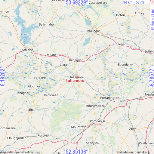
Tullamore GPS coordinates[2]
53° 16' 26.004" North, 7° 29' 20.004" West
| Map corner | latitude | longitude |
|---|---|---|
| Upper-left | 53.69229°, | -8.19202° |
| Center: | 53.27389°, | -7.48889° |
| Lower-right: | 52.85136°, | -6.78577° |
| Map W x H: | 93.5×93.5 km | = 58.1×58.1mi |
| max Lat: | 55.25° ⇑49.1% North |
| Tullamore: | 53.27389° |
| min Lat: | ⇓50.9% South 51.52487° |
| min Long | Tullamore | max Long |
| -10.26889° | -7.48889° | -6.04944° |
| W 47.8%⇐ | ⇒52.2% E |
Elevation
Elevation of Tullamore is 60 m = 197 ft, and this is 5.5 m = 18 ft above average elevation for this country.
| Max E: |
262 m = 860 ft | 40.2% |
| Tullamore | 60 m 197 ft | |
| Avg. | 54.5 m = 179 ft | |
Min E: |
0 m = 0 ft | 59.8% |
See also: Ireland elevation on elevation.city.
Geographical zone
Tullamore is located in North temperate zone (between Tropic of Cancer and the Arctic Circle). Distance of this North polar circle is 1477.7 km =918.2 mi to North.| Distance of | km | miles | from Tullamore |
|---|---|---|---|
| North Pole | 4083.6 | 2537.4 | to North |
| Arctic Circle | 1477.7 | 918.2 | to North |
| Tropic Cancer | 3317.6 | 2061.5 | to South |
| Equator | 5923.5 | 3680.7 | to South |


Nearby cities:
15 places around Tullamore: (largest is in red/bold)
• Clara
11.3 km =7 mi,  312°
312°
• Cloghan
26.9 km =16.7 mi,  257°
257°
• Clonaslee
14.3 km =8.9 mi,  189°
189°
• Daingean
13.5 km =8.4 mi,  79°
79°
• Ferbane
22.5 km =14 mi,  268°
268°
• Kilbeggan
10.7 km =6.6 mi,  354°
354°
• Kilcormac
19.3 km =12 mi,  234°
234°
• Killenard
27.5 km =17.1 mi,  124°
124°
• Moate
20.2 km =12.6 mi, 311°
• Mountmellick
21.1 km =13.1 mi,  147°
147°
• Portarlington
23.4 km =14.5 mi, 122°
• Portlaoise
29.5 km =18.3 mi, 154°
• Rhode
21 km =13 mi,  65°
65°
• Rochfortbridge
20.2 km =12.6 mi,  39°
39°
• Tyrrellspass
14.9 km =9.3 mi,  30°
30°
Sources, notices
• [Note1] Compared only with cities in Ireland existing in our database
• [Src1] Map data: © OpenStreetMap contributors (CC-BY-SA)
• [Src2] Other city data from geonames.org with taken over terms of usage.
• [Src3] Geographical zone / Annual Mean Temperature by Robert A. Rohde @ Wikipedia
