Kilcormac geodata
Kilcormac (Leinster) is a populated place; located in Ireland in Europe/Dublin (GMT+1) time zone. With population of 870 people, there are 375 cities with bigger population in this country. Compared to other cities in Ireland, 54.1% of cities are located further ↑North; 57.1% of cities are located further →East and 65.1% of cities have lower elevation than Kilcormac. Note1


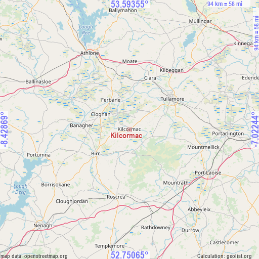
Kilcormac GPS coordinates[2]
53° 10' 27.012" North, 7° 43' 32.016" West
| Map corner | latitude | longitude |
|---|---|---|
| Upper-left | 53.59355°, | -8.42869° |
| Center: | 53.17417°, | -7.72556° |
| Lower-right: | 52.75065°, | -7.02244° |
| Map W x H: | 93.7×93.7 km | = 58.2×58.2mi |
| max Lat: | 55.25° ⇑54.1% North |
| Kilcormac: | 53.17417° |
| min Lat: | ⇓45.9% South 51.52487° |
| min Long | Kilcormac | max Long |
| -10.26889° | -7.72556° | -6.04944° |
| W 42.9%⇐ | ⇒57.1% E |
Elevation
Elevation of Kilcormac is 64 m = 210 ft, and this is 9.5 m = 31 ft above average elevation for this country.
| Max E: |
262 m = 860 ft | 34.9% |
| Kilcormac | 64 m 210 ft | |
| Avg. | 54.5 m = 179 ft | |
Min E: |
0 m = 0 ft | 65.1% |
See also: Ireland elevation on elevation.city.
Geographical zone
Kilcormac is located in North temperate zone (between Tropic of Cancer and the Arctic Circle). Distance of this North polar circle is 1488.8 km =925.1 mi to North.| Distance of | km | miles | from Kilcormac |
|---|---|---|---|
| North Pole | 4094.6 | 2544.3 | to North |
| Arctic Circle | 1488.8 | 925.1 | to North |
| Tropic Cancer | 3306.5 | 2054.6 | to South |
| Equator | 5912.4 | 3673.8 | to South |


Nearby cities:
15 places around Kilcormac: (largest is in red/bold)
• Banagher
17.5 km =10.9 mi,  275°
275°
• Birr
15.5 km =9.6 mi,  233°
233°
• Clara
20.1 km =12.5 mi,  21°
21°
• Cloghan
11.8 km =7.3 mi,  296°
296°
• Clonaslee
13.7 km =8.5 mi,  102°
102°
• Daingean
32 km =19.9 mi,  64°
64°
• Ferbane
12.6 km =7.8 mi,  327°
327°
• Kilbeggan
26.3 km =16.3 mi,  34°
34°
• Moate
24.4 km =15.2 mi,  1°
1°
• Mountmellick
27.9 km =17.3 mi, 103°
• Mountrath
25.8 km =16 mi,  139°
139°
• Portlaoise
32.4 km =20.1 mi,  118°
118°
• Roscrea
25.3 km =15.7 mi,  191°
191°
• Shinrone
25.1 km =15.6 mi,  211°
211°
• Tullamore
19.3 km =12 mi,  54°
54°
Sources, notices
• [Note1] Compared only with cities in Ireland existing in our database
• [Src1] Map data: © OpenStreetMap contributors (CC-BY-SA)
• [Src2] Other city data from geonames.org with taken over terms of usage.
• [Src3] Geographical zone / Annual Mean Temperature by Robert A. Rohde @ Wikipedia
