Kilbeggan geodata
Kilbeggan (Leinster) is a populated place; located in Ireland in Europe/Dublin (GMT+1) time zone. With population of 1,199 people, there are 312 cities with bigger population in this country. Compared to other cities in Ireland, 62.4% of cities are located further ↓South; 52.6% of cities are located further →East and 67.7% of cities have lower elevation than Kilbeggan. Note1


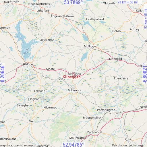
Kilbeggan GPS coordinates[2]
53° 22' 9.984" North, 7° 30' 11.988" West
| Map corner | latitude | longitude |
|---|---|---|
| Upper-left | 53.7869°, | -8.20646° |
| Center: | 53.36944°, | -7.50333° |
| Lower-right: | 52.94785°, | -6.80021° |
| Map W x H: | 93.3×93.3 km | = 58×58mi |
| max Lat: | 55.25° ⇑37.6% North |
| Kilbeggan: | 53.36944° |
| min Lat: | ⇓62.4% South 51.52487° |
| min Long | Kilbeggan | max Long |
| -10.26889° | -7.50333° | -6.04944° |
| W 47.4%⇐ | ⇒52.6% E |
Elevation
Elevation of Kilbeggan is 67 m = 220 ft, and this is 12.5 m = 41 ft above average elevation for this country.
| Max E: |
262 m = 860 ft | 32.3% |
| Kilbeggan | 67 m 220 ft | |
| Avg. | 54.5 m = 179 ft | |
Min E: |
0 m = 0 ft | 67.7% |
See also: Ireland elevation on elevation.city.
Geographical zone
Kilbeggan is located in North temperate zone (between Tropic of Cancer and the Arctic Circle). Distance of this North polar circle is 1467 km =911.6 mi to North.| Distance of | km | miles | from Kilbeggan |
|---|---|---|---|
| North Pole | 4072.9 | 2530.8 | to North |
| Arctic Circle | 1467 | 911.6 | to North |
| Tropic Cancer | 3328.2 | 2068 | to South |
| Equator | 5934.1 | 3687.3 | to South |


Nearby cities:
15 places around Kilbeggan: (largest is in red/bold)
• An Muileann gCearr
20.4 km =12.7 mi,  32°
32°
• Ballymahon
28 km =17.4 mi,  321°
321°
• Clara
7.9 km =4.9 mi,  247°
247°
• Clonaslee
24.7 km =15.3 mi,  183°
183°
• Daingean
16.4 km =10.2 mi,  119°
119°
• Ferbane
24.2 km =15 mi,  242°
242°
• Kilcormac
26.3 km =16.3 mi,  214°
214°
• Kinnegad
28.3 km =17.6 mi,  71°
71°
• Moate
14.4 km =8.9 mi,  280°
280°
• Moate
24.5 km =15.2 mi, 324°
• Rathwire
28.8 km =17.9 mi,  57°
57°
• Rhode
20.1 km =12.5 mi,  95°
95°
• Rochfortbridge
14.6 km =9.1 mi, 70°
• Tullamore
10.7 km =6.6 mi,  174°
174°
• Tyrrellspass
8.9 km =5.5 mi,  75°
75°
Sources, notices
• [Note1] Compared only with cities in Ireland existing in our database
• [Src1] Map data: © OpenStreetMap contributors (CC-BY-SA)
• [Src2] Other city data from geonames.org with taken over terms of usage.
• [Src3] Geographical zone / Annual Mean Temperature by Robert A. Rohde @ Wikipedia
