Ballinamore geodata
Ballinamore (Connaught) is a populated place; located in Ireland in Europe/Dublin (GMT+1) time zone. With population of 889 people, there are 368 cities with bigger population in this country. Compared to other cities in Ireland, 88.4% of cities are located further ↓South; 58.8% of cities are located further →East and 76.3% of cities have lower elevation than Ballinamore. Note1


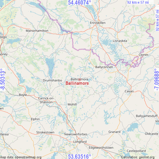
Ballinamore GPS coordinates[2]
54° 3' 0" North, 7° 48' 0" West
| Map corner | latitude | longitude |
|---|---|---|
| Upper-left | 54.46074°, | -8.50313° |
| Center: | 54.05°, | -7.8° |
| Lower-right: | 53.63516°, | -7.09688° |
| Map W x H: | 91.8×91.8 km | = 57×57mi |
| max Lat: | 55.25° ⇑11.6% North |
| Ballinamore: | 54.05° |
| min Lat: | ⇓88.4% South 51.52487° |
| min Long | Ballinamore | max Long |
| -10.26889° | -7.8° | -6.04944° |
| W 41.2%⇐ | ⇒58.8% E |
Elevation
Elevation of Ballinamore is 82 m = 269 ft, and this is 27.5 m = 90 ft above average elevation for this country.
| Max E: |
262 m = 860 ft | 23.7% |
| Ballinamore | 82 m 269 ft | |
| Avg. | 54.5 m = 179 ft | |
Min E: |
0 m = 0 ft | 76.3% |
See also: Ireland elevation on elevation.city.
Geographical zone
Ballinamore is located in North temperate zone (between Tropic of Cancer and the Arctic Circle). Distance of this North polar circle is 1391.4 km =864.6 mi to North.| Distance of | km | miles | from Ballinamore |
|---|---|---|---|
| North Pole | 3997.3 | 2483.8 | to North |
| Arctic Circle | 1391.4 | 864.6 | to North |
| Tropic Cancer | 3403.9 | 2115.1 | to South |
| Equator | 6009.8 | 3734.3 | to South |


Nearby cities:
15 places around Ballinamore: (largest is in red/bold)
• Ballinagh
28.2 km =17.5 mi,  117°
117°
• Ballyconnell
16 km =9.9 mi,  62°
62°
• Ballyhaise
31.6 km =19.6 mi,  90°
90°
• Belturbet
23.5 km =14.6 mi,  76°
76°
• Boyle
34 km =21.1 mi,  254°
254°
• Carrick-on-Shannon
22.1 km =13.7 mi,  238°
238°
• Cavan
29.5 km =18.3 mi,  102°
102°
• Drumlish
26 km =16.2 mi,  175°
175°
• Drumshanbo
15.2 km =9.4 mi,  270°
270°
• Elphin
34.3 km =21.3 mi,  229°
229°
• Longford
36.1 km =22.4 mi, 179°
• Mohill
15.5 km =9.6 mi,  196°
196°
• Newtownforbes
31.5 km =19.6 mi, 184°
• Roosky
25.3 km =15.7 mi, 197°
• Strokestown
35.6 km =22.1 mi,  213°
213°
Sources, notices
• [Note1] Compared only with cities in Ireland existing in our database
• [Src1] Map data: © OpenStreetMap contributors (CC-BY-SA)
• [Src2] Other city data from geonames.org with taken over terms of usage.
• [Src3] Geographical zone / Annual Mean Temperature by Robert A. Rohde @ Wikipedia
