Slane geodata
Slane (Leinster) is a populated place; located in Ireland in Europe/Dublin (GMT+1) time zone. With population of 1,349 people, there are 294 cities with bigger population in this country. Compared to other cities in Ireland, 78.6% of cities are located further ↓South; 72.5% of cities are located further ←West and 62.6% of cities have lower elevation than Slane. Note1


Slane GPS coordinates[2]
53° 42' 36" North, 6° 32' 35.988" West
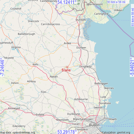
| Map corner | latitude | longitude |
|---|---|---|
| Upper-left | 54.12411°, | -7.24646° |
| Center: | 53.71°, | -6.54333° |
| Lower-right: | 53.29178°, | -5.84021° |
| Map W x H: | 92.5×92.5 km | = 57.5×57.5mi |
| max Lat: | 55.25° ⇑21.4% North |
| Slane: | 53.71° |
| min Lat: | ⇓78.6% South 51.52487° |
| min Long | Slane | max Long |
| -10.26889° | -6.54333° | -6.04944° |
| W 72.5%⇐ | ⇒27.5% E |
Elevation
Elevation of Slane is 62 m = 203 ft, and this is 7.5 m = 25 ft above average elevation for this country.
| Max E: |
262 m = 860 ft | 37.4% |
| Slane | 62 m 203 ft | |
| Avg. | 54.5 m = 179 ft | |
Min E: |
0 m = 0 ft | 62.6% |
See also: Ireland elevation on elevation.city.
Geographical zone
Slane is located in North temperate zone (between Tropic of Cancer and the Arctic Circle). Distance of this North polar circle is 1429.2 km =888.1 mi to North.| Distance of | km | miles | from Slane |
|---|---|---|---|
| North Pole | 4035.1 | 2507.3 | to North |
| Arctic Circle | 1429.2 | 888.1 | to North |
| Tropic Cancer | 3366.1 | 2091.6 | to South |
| Equator | 5972 | 3710.8 | to South |


Nearby cities:
15 places around Slane: (largest is in red/bold)
• Ardee
16.6 km =10.3 mi,  0°
0°
• Carlanstown
20.3 km =12.6 mi,  285°
285°
• Collon
8.7 km =5.4 mi,  25°
25°
• Donore
8.4 km =5.2 mi,  103°
103°
• Drogheda
12.9 km =8 mi,  85°
85°
• Duleek
10.1 km =6.3 mi,  125°
125°
• Dunleer
16.9 km =10.5 mi, 34°
• Julianstown
17.5 km =10.9 mi, 103°
• Kentstown
9.2 km =5.7 mi,  173°
173°
• Kilmessan
18.5 km =11.5 mi,  204°
204°
• Laytown
20.3 km =12.6 mi, 98°
• Navan
11.1 km =6.9 mi,  235°
235°
• Stamullin
20.2 km =12.6 mi,  116°
116°
• Termonfeckin
19.1 km =11.9 mi,  71°
71°
• Tullyallen
8.4 km =5.2 mi, 69°
Sources, notices
• [Note1] Compared only with cities in Ireland existing in our database
• [Src1] Map data: © OpenStreetMap contributors (CC-BY-SA)
• [Src2] Other city data from geonames.org with taken over terms of usage.
• [Src3] Geographical zone / Annual Mean Temperature by Robert A. Rohde @ Wikipedia
