Kanturk geodata
Kanturk (Munster) is a populated place; located in Ireland in Europe/Dublin (GMT+1) time zone. With population of 2,263 people, there are 218 cities with bigger population in this country. Compared to other cities in Ireland, 89.2% of cities are located further ↑North; 86.5% of cities are located further →East and 74.8% of cities have lower elevation than Kanturk. Note1


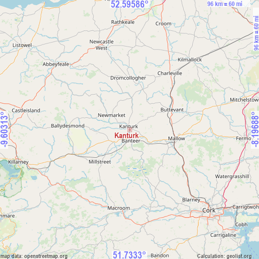
Kanturk GPS coordinates[2]
52° 10' 0.012" North, 8° 54' 0" West
| Map corner | latitude | longitude |
|---|---|---|
| Upper-left | 52.59586°, | -9.60313° |
| Center: | 52.16667°, | -8.9° |
| Lower-right: | 51.7333°, | -8.19688° |
| Map W x H: | 95.9×95.9 km | = 59.6×59.6mi |
| max Lat: | 55.25° ⇑89.2% North |
| Kanturk: | 52.16667° |
| min Lat: | ⇓10.8% South 51.52487° |
| min Long | Kanturk | max Long |
| -10.26889° | -8.9° | -6.04944° |
| W 13.5%⇐ | ⇒86.5% E |
Elevation
Elevation of Kanturk is 79 m = 259 ft, and this is 24.5 m = 80 ft above average elevation for this country.
| Max E: |
262 m = 860 ft | 25.2% |
| Kanturk | 79 m 259 ft | |
| Avg. | 54.5 m = 179 ft | |
Min E: |
0 m = 0 ft | 74.8% |
See also: Ireland elevation on elevation.city.
Geographical zone
Kanturk is located in North temperate zone (between Tropic of Cancer and the Arctic Circle). Distance of this North polar circle is 1600.8 km =994.7 mi to North.| Distance of | km | miles | from Kanturk |
|---|---|---|---|
| North Pole | 4206.7 | 2613.9 | to North |
| Arctic Circle | 1600.8 | 994.7 | to North |
| Tropic Cancer | 3194.5 | 1985 | to South |
| Equator | 5800.4 | 3604.2 | to South |


Nearby cities:
15 places around Kanturk: (largest is in red/bold)
• Bruree
32.6 km =20.3 mi,  29°
29°
• Buttevant
17.5 km =10.9 mi,  65°
65°
• Churchtown
15.9 km =9.9 mi,  45°
45°
• Courtbrack
28.2 km =17.5 mi,  142°
142°
• Doneraile
22.3 km =13.9 mi,  75°
75°
• Dromcollogher
19.2 km =11.9 mi,  358°
358°
• Drommahane
15.8 km =9.8 mi,  115°
115°
• Grenagh
26.1 km =16.2 mi,  130°
130°
• Macroom
29.3 km =18.2 mi,  189°
189°
• Mallow
18.6 km =11.6 mi,  101°
101°
• Millstreet
16.2 km =10.1 mi,  222°
222°
• Newcastle West
33.3 km =20.7 mi,  340°
340°
• Newmarket
8.8 km =5.5 mi,  309°
309°
• Rathmore
23.5 km =14.6 mi,  246°
246°
• Ráth Luirc
25.2 km =15.7 mi,  35°
35°
Sources, notices
• [Note1] Compared only with cities in Ireland existing in our database
• [Src1] Map data: © OpenStreetMap contributors (CC-BY-SA)
• [Src2] Other city data from geonames.org with taken over terms of usage.
• [Src3] Geographical zone / Annual Mean Temperature by Robert A. Rohde @ Wikipedia
