Dromcollogher geodata
Dromcollogher (Munster) is a populated place; located in Ireland in Europe/Dublin (GMT+1) time zone. With population of 548 people, there are 501 cities with bigger population in this country. Compared to other cities in Ireland, 84.4% of cities are located further ↑North; 86.7% of cities are located further →East and 94.5% of cities have lower elevation than Dromcollogher. Note1


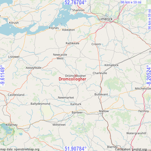
Dromcollogher GPS coordinates[2]
52° 20' 22.308" North, 8° 54' 30.132" West
| Map corner | latitude | longitude |
|---|---|---|
| Upper-left | 52.76704°, | -9.61149° |
| Center: | 52.33953°, | -8.90837° |
| Lower-right: | 51.90784°, | -8.20524° |
| Map W x H: | 95.5×95.5 km | = 59.3×59.3mi |
| max Lat: | 55.25° ⇑84.4% North |
| Dromcollogher: | 52.33953° |
| min Lat: | ⇓15.6% South 51.52487° |
| min Long | Dromcollogher | max Long |
| -10.26889° | -8.90837° | -6.04944° |
| W 13.3%⇐ | ⇒86.7% E |
Elevation
Elevation of Dromcollogher is 119 m = 390 ft, and this is 64.5 m = 212 ft above average elevation for this country.
| Max E: |
262 m = 860 ft | 5.5% |
| Dromcollogher | 119 m 390 ft | |
| Avg. | 54.5 m = 179 ft | |
Min E: |
0 m = 0 ft | 94.5% |
See also: Ireland elevation on elevation.city.
Geographical zone
Dromcollogher is located in North temperate zone (between Tropic of Cancer and the Arctic Circle). Distance of this North polar circle is 1581.6 km =982.8 mi to North.| Distance of | km | miles | from Dromcollogher |
|---|---|---|---|
| North Pole | 4187.5 | 2602 | to North |
| Arctic Circle | 1581.6 | 982.8 | to North |
| Tropic Cancer | 3213.7 | 1996.9 | to South |
| Equator | 5819.6 | 3616.1 | to South |


Nearby cities:
15 places around Dromcollogher: (largest is in red/bold)
• Abbeyfeale
27.2 km =16.9 mi,  279°
279°
• Adare
25.9 km =16.1 mi,  17°
17°
• Ballingarry
15.1 km =9.4 mi,  11°
11°
• Bruff
28.8 km =17.9 mi,  58°
58°
• Bruree
18.9 km =11.7 mi, 61°
• Buttevant
20.2 km =12.6 mi,  125°
125°
• Churchtown
14.4 km =8.9 mi,  124°
124°
• Croom
23.8 km =14.8 mi,  32°
32°
• Doneraile
26 km =16.2 mi, 121°
• Kanturk
19.2 km =11.9 mi,  178°
178°
• Kilmallock
23.5 km =14.6 mi,  73°
73°
• Newcastle West
16 km =9.9 mi,  319°
319°
• Newmarket
15 km =9.3 mi,  204°
204°
• Rathkeale
20.7 km =12.9 mi,  354°
354°
• Ráth Luirc
15.3 km =9.5 mi,  85°
85°
Sources, notices
• [Note1] Compared only with cities in Ireland existing in our database
• [Src1] Map data: © OpenStreetMap contributors (CC-BY-SA)
• [Src2] Other city data from geonames.org with taken over terms of usage.
• [Src3] Geographical zone / Annual Mean Temperature by Robert A. Rohde @ Wikipedia
