Churchtown geodata
Churchtown (Munster) is a populated place; located in Ireland in Europe/Dublin (GMT+1) time zone. With population of 509 people, there are 519 cities with bigger population in this country. Compared to other cities in Ireland, 86.7% of cities are located further ↑North; 82.5% of cities are located further →East and 89.4% of cities have lower elevation than Churchtown. Note1


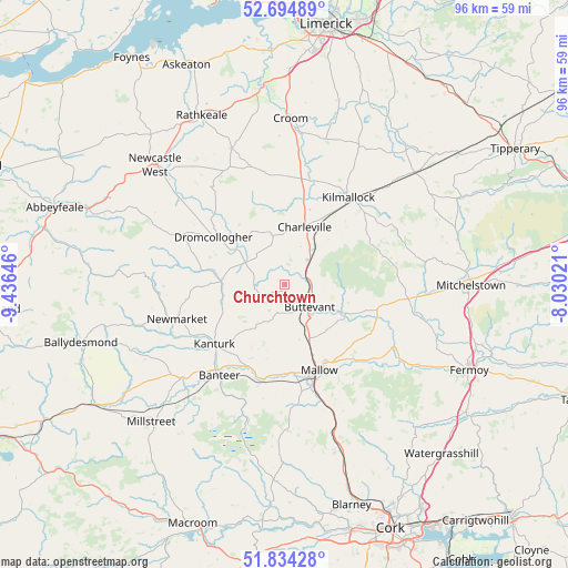
Churchtown GPS coordinates[2]
52° 16' 0.012" North, 8° 43' 59.988" West
| Map corner | latitude | longitude |
|---|---|---|
| Upper-left | 52.69489°, | -9.43646° |
| Center: | 52.26667°, | -8.73333° |
| Lower-right: | 51.83428°, | -8.03021° |
| Map W x H: | 95.7×95.7 km | = 59.5×59.5mi |
| max Lat: | 55.25° ⇑86.7% North |
| Churchtown: | 52.26667° |
| min Lat: | ⇓13.3% South 51.52487° |
| min Long | Churchtown | max Long |
| -10.26889° | -8.73333° | -6.04944° |
| W 17.5%⇐ | ⇒82.5% E |
Elevation
Elevation of Churchtown is 103 m = 338 ft, and this is 48.5 m = 159 ft above average elevation for this country.
| Max E: |
262 m = 860 ft | 10.6% |
| Churchtown | 103 m 338 ft | |
| Avg. | 54.5 m = 179 ft | |
Min E: |
0 m = 0 ft | 89.4% |
See also: Ireland elevation on elevation.city.
Geographical zone
Churchtown is located in North temperate zone (between Tropic of Cancer and the Arctic Circle). Distance of this North polar circle is 1589.7 km =987.8 mi to North.| Distance of | km | miles | from Churchtown |
|---|---|---|---|
| North Pole | 4195.6 | 2607 | to North |
| Arctic Circle | 1589.7 | 987.8 | to North |
| Tropic Cancer | 3205.6 | 1991.9 | to South |
| Equator | 5811.5 | 3611.1 | to South |


Nearby cities:
15 places around Churchtown: (largest is in red/bold)
• Ballingarry
24.6 km =15.3 mi,  338°
338°
• Bruff
26.4 km =16.4 mi,  28°
28°
• Bruree
17.9 km =11.1 mi,  15°
15°
• Buttevant
5.9 km =3.7 mi,  129°
129°
• Croom
28.1 km =17.5 mi,  2°
2°
• Doneraile
11.6 km =7.2 mi,  118°
118°
• Dromcollogher
14.4 km =8.9 mi,  304°
304°
• Drommahane
18.2 km =11.3 mi,  170°
170°
• Glanworth
27.1 km =16.8 mi,  109°
109°
• Kanturk
15.9 km =9.9 mi,  225°
225°
• Kilfinnane
20.7 km =12.9 mi,  60°
60°
• Kilmallock
18.2 km =11.3 mi,  35°
35°
• Mallow
16.3 km =10.1 mi,  155°
155°
• Newmarket
19 km =11.8 mi,  252°
252°
• Ráth Luirc
9.9 km =6.2 mi, 20°
Sources, notices
• [Note1] Compared only with cities in Ireland existing in our database
• [Src1] Map data: © OpenStreetMap contributors (CC-BY-SA)
• [Src2] Other city data from geonames.org with taken over terms of usage.
• [Src3] Geographical zone / Annual Mean Temperature by Robert A. Rohde @ Wikipedia
