Millstreet geodata
Millstreet (Munster) is a populated place; located in Ireland in Europe/Dublin (GMT+1) time zone. With population of 1,574 people, there are 261 cities with bigger population in this country. Compared to other cities in Ireland, 92% of cities are located further ↑North; 90.1% of cities are located further →East and 95.4% of cities have lower elevation than Millstreet. Note1


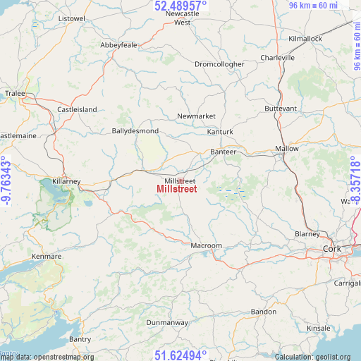
Millstreet GPS coordinates[2]
52° 3' 33.66" North, 9° 3' 37.116" West
| Map corner | latitude | longitude |
|---|---|---|
| Upper-left | 52.48957°, | -9.76343° |
| Center: | 52.05935°, | -9.06031° |
| Lower-right: | 51.62494°, | -8.35718° |
| Map W x H: | 96.1×96.1 km | = 59.7×59.7mi |
| max Lat: | 55.25° ⇑92% North |
| Millstreet: | 52.05935° |
| min Lat: | ⇓8% South 51.52487° |
| min Long | Millstreet | max Long |
| -10.26889° | -9.06031° | -6.04944° |
| W 9.9%⇐ | ⇒90.1% E |
Elevation
Elevation of Millstreet is 129 m = 423 ft, and this is 74.5 m = 244 ft above average elevation for this country.
| Max E: |
262 m = 860 ft | 4.6% |
| Millstreet | 129 m 423 ft | |
| Avg. | 54.5 m = 179 ft | |
Min E: |
0 m = 0 ft | 95.4% |
See also: Ireland elevation on elevation.city.
Geographical zone
Millstreet is located in North temperate zone (between Tropic of Cancer and the Arctic Circle). Distance of this North polar circle is 1612.7 km =1002.1 mi to North.| Distance of | km | miles | from Millstreet |
|---|---|---|---|
| North Pole | 4218.6 | 2621.3 | to North |
| Arctic Circle | 1612.7 | 1002.1 | to North |
| Tropic Cancer | 3182.5 | 1977.5 | to South |
| Equator | 5788.5 | 3596.8 | to South |


Nearby cities:
15 places around Millstreet: (largest is in red/bold)
• Buttevant
33.1 km =20.6 mi,  54°
54°
• Castleisland
33.8 km =21 mi,  304°
304°
• Churchtown
32.1 km =19.9 mi,  44°
44°
• Cill Airne
30.6 km =19 mi,  270°
270°
• Courtbrack
30.2 km =18.8 mi,  109°
109°
• Dromcollogher
32.8 km =20.4 mi,  18°
18°
• Drommahane
25.7 km =16 mi,  78°
78°
• Grenagh
31.3 km =19.4 mi,  99°
99°
• Kanturk
16.2 km =10.1 mi, 42°
• Macroom
18.1 km =11.2 mi,  159°
159°
• Mallow
30.3 km =18.8 mi,  74°
74°
• Newmarket
18 km =11.2 mi,  13°
13°
• Rathard
32.2 km =20 mi,  136°
136°
• Rathmore
11 km =6.8 mi,  284°
284°
• Tower
34.4 km =21.4 mi,  115°
115°
Sources, notices
• [Note1] Compared only with cities in Ireland existing in our database
• [Src1] Map data: © OpenStreetMap contributors (CC-BY-SA)
• [Src2] Other city data from geonames.org with taken over terms of usage.
• [Src3] Geographical zone / Annual Mean Temperature by Robert A. Rohde @ Wikipedia
