Newmarket geodata
Newmarket (Munster) is a populated place; located in Ireland in Europe/Dublin (GMT+1) time zone. With population of 988 people, there are 352 cities with bigger population in this country. Compared to other cities in Ireland, 88.4% of cities are located further ↑North; 89.4% of cities are located further →East and 97.9% of cities have lower elevation than Newmarket. Note1


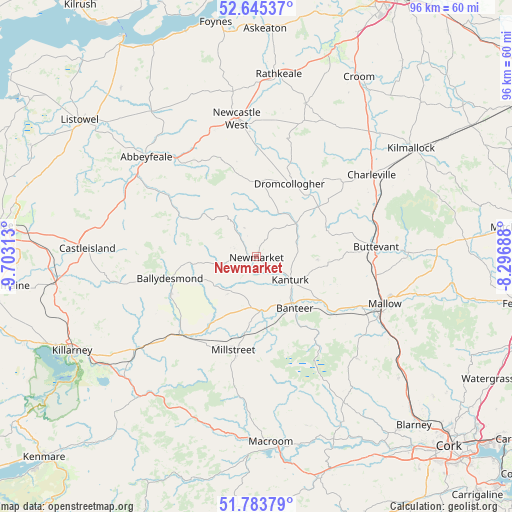
Newmarket GPS coordinates[2]
52° 13' 0.012" North, 9° 0' 0" West
| Map corner | latitude | longitude |
|---|---|---|
| Upper-left | 52.64537°, | -9.70313° |
| Center: | 52.21667°, | -9° |
| Lower-right: | 51.78379°, | -8.29688° |
| Map W x H: | 95.8×95.8 km | = 59.5×59.5mi |
| max Lat: | 55.25° ⇑88.4% North |
| Newmarket: | 52.21667° |
| min Lat: | ⇓11.6% South 51.52487° |
| min Long | Newmarket | max Long |
| -10.26889° | -9° | -6.04944° |
| W 10.6%⇐ | ⇒89.4% E |
Elevation
Elevation of Newmarket is 159 m = 522 ft, and this is 104.5 m = 343 ft above average elevation for this country.
| Max E: |
262 m = 860 ft | 2.1% |
| Newmarket | 159 m 522 ft | |
| Avg. | 54.5 m = 179 ft | |
Min E: |
0 m = 0 ft | 97.9% |
See also: Ireland elevation on elevation.city.
Geographical zone
Newmarket is located in North temperate zone (between Tropic of Cancer and the Arctic Circle). Distance of this North polar circle is 1595.2 km =991.2 mi to North.| Distance of | km | miles | from Newmarket |
|---|---|---|---|
| North Pole | 4201.1 | 2610.4 | to North |
| Arctic Circle | 1595.2 | 991.2 | to North |
| Tropic Cancer | 3200 | 1988.4 | to South |
| Equator | 5805.9 | 3607.6 | to South |


Nearby cities:
15 places around Newmarket: (largest is in red/bold)
• Abbeyfeale
27.5 km =17.1 mi,  311°
311°
• Ballingarry
29.9 km =18.6 mi,  17°
17°
• Bruree
32.3 km =20.1 mi,  45°
45°
• Buttevant
22.8 km =14.2 mi,  85°
85°
• Castleisland
31.8 km =19.8 mi,  273°
273°
• Churchtown
19 km =11.8 mi,  72°
72°
• Doneraile
28.4 km =17.6 mi, 90°
• Dromcollogher
15 km =9.3 mi, 24°
• Drommahane
24.5 km =15.2 mi,  120°
120°
• Kanturk
8.8 km =5.5 mi,  129°
129°
• Mallow
26.7 km =16.6 mi,  110°
110°
• Millstreet
18 km =11.2 mi,  193°
193°
• Newcastle West
26.2 km =16.3 mi,  350°
350°
• Rathmore
20.9 km =13 mi,  224°
224°
• Ráth Luirc
26.1 km =16.2 mi,  55°
55°
Sources, notices
• [Note1] Compared only with cities in Ireland existing in our database
• [Src1] Map data: © OpenStreetMap contributors (CC-BY-SA)
• [Src2] Other city data from geonames.org with taken over terms of usage.
• [Src3] Geographical zone / Annual Mean Temperature by Robert A. Rohde @ Wikipedia
