Stradbally geodata
Stradbally (Leinster) is a populated place; located in Ireland in Europe/Dublin (GMT+0) time zone. With population of 1,154 people, there are 323 cities with bigger population in this country. Compared to other cities in Ireland, 60.5% of cities are located further ↑North; 55.4% of cities are located further ←West and 79.1% of cities have lower elevation than Stradbally. Note1


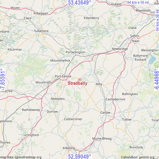
Stradbally GPS coordinates[2]
53° 0' 56.016" North, 7° 9' 10.008" West
| Map corner | latitude | longitude |
|---|---|---|
| Upper-left | 53.43649°, | -7.85591° |
| Center: | 53.01556°, | -7.15278° |
| Lower-right: | 52.59049°, | -6.44966° |
| Map W x H: | 94.1×94.1 km | = 58.5×58.5mi |
| max Lat: | 55.25° ⇑60.5% North |
| Stradbally: | 53.01556° |
| min Lat: | ⇓39.5% South 51.52487° |
| min Long | Stradbally | max Long |
| -10.26889° | -7.15278° | -6.04944° |
| W 55.4%⇐ | ⇒44.6% E |
Elevation
Elevation of Stradbally is 87 m = 285 ft, and this is 32.5 m = 107 ft above average elevation for this country.
| Max E: |
262 m = 860 ft | 20.9% |
| Stradbally | 87 m 285 ft | |
| Avg. | 54.5 m = 179 ft | |
Min E: |
0 m = 0 ft | 79.1% |
See also: Ireland elevation on elevation.city.
Geographical zone
Stradbally is located in North temperate zone (between Tropic of Cancer and the Arctic Circle). Distance of this North polar circle is 1506.4 km =936 mi to North.| Distance of | km | miles | from Stradbally |
|---|---|---|---|
| North Pole | 4112.3 | 2555.3 | to North |
| Arctic Circle | 1506.4 | 936 | to North |
| Tropic Cancer | 3288.9 | 2043.6 | to South |
| Equator | 5894.8 | 3662.9 | to South |


Nearby cities:
15 places around Stradbally: (largest is in red/bold)
• Abbeyleix
17.2 km =10.7 mi,  228°
228°
• Athy
11.9 km =7.4 mi,  103°
103°
• Ballitore
22.3 km =13.9 mi,  92°
92°
• Ballylinan
10.9 km =6.8 mi,  136°
136°
• Cherryville
20 km =12.4 mi,  38°
38°
• Kildare
22.3 km =13.9 mi,  45°
45°
• Killenard
13.1 km =8.1 mi,  1°
1°
• Monasterevin
15 km =9.3 mi,  22°
22°
• Moneenroe
19.5 km =12.1 mi,  180°
180°
• Moone
23 km =14.3 mi, 101°
• Mountmellick
15.6 km =9.7 mi,  314°
314°
• Mountrath
21.5 km =13.4 mi,  265°
265°
• Portarlington
16.5 km =10.3 mi,  351°
351°
• Portlaoise
10.1 km =6.3 mi,  282°
282°
• Suncroft
21.8 km =13.5 mi,  63°
63°
Sources, notices
• [Note1] Compared only with cities in Ireland existing in our database
• [Src1] Map data: © OpenStreetMap contributors (CC-BY-SA)
• [Src2] Other city data from geonames.org with taken over terms of usage.
• [Src3] Geographical zone / Annual Mean Temperature by Robert A. Rohde @ Wikipedia
