Cappamore geodata
Cappamore (Munster) is a populated place; located in Ireland in Europe/Dublin (GMT+1) time zone. With population of 675 people, there are 440 cities with bigger population in this country. Compared to other cities in Ireland, 75.3% of cities are located further ↑North; 70.6% of cities are located further →East and 56.5% of cities have lower elevation than Cappamore. Note1


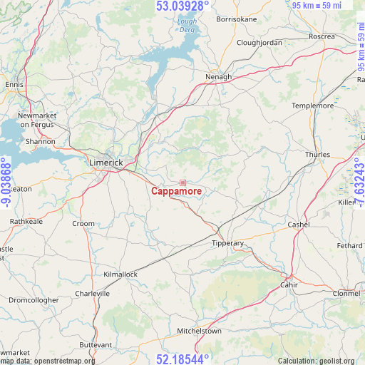
Cappamore GPS coordinates[2]
52° 36' 51.984" North, 8° 20' 8.016" West
| Map corner | latitude | longitude |
|---|---|---|
| Upper-left | 53.03928°, | -9.03868° |
| Center: | 52.61444°, | -8.33556° |
| Lower-right: | 52.18544°, | -7.63243° |
| Map W x H: | 94.9×94.9 km | = 59×59mi |
| max Lat: | 55.25° ⇑75.3% North |
| Cappamore: | 52.61444° |
| min Lat: | ⇓24.7% South 51.52487° |
| min Long | Cappamore | max Long |
| -10.26889° | -8.33556° | -6.04944° |
| W 29.4%⇐ | ⇒70.6% E |
Elevation
Elevation of Cappamore is 57 m = 187 ft, and this is 2.5 m = 8 ft above average elevation for this country.
| Max E: |
262 m = 860 ft | 43.5% |
| Cappamore | 57 m 187 ft | |
| Avg. | 54.5 m = 179 ft | |
Min E: |
0 m = 0 ft | 56.5% |
See also: Ireland elevation on elevation.city.
Geographical zone
Cappamore is located in North temperate zone (between Tropic of Cancer and the Arctic Circle). Distance of this North polar circle is 1551 km =963.7 mi to North.| Distance of | km | miles | from Cappamore |
|---|---|---|---|
| North Pole | 4156.9 | 2583 | to North |
| Arctic Circle | 1551 | 963.7 | to North |
| Tropic Cancer | 3244.3 | 2015.9 | to South |
| Equator | 5850.2 | 3635.1 | to South |


Nearby cities:
15 places around Cappamore: (largest is in red/bold)
• Annacotty
14.5 km =9 mi,  294°
294°
• Ardnacrusha
21.5 km =13.4 mi,  299°
299°
• Ballina
22.5 km =14 mi,  342°
342°
• Bruff
21.1 km =13.1 mi,  222°
222°
• Caherconlish
9.4 km =5.8 mi,  255°
255°
• Castleconnell
15.6 km =9.7 mi,  315°
315°
• Clonlara
19.1 km =11.9 mi,  309°
309°
• Doon
6.3 km =3.9 mi,  101°
101°
• Hospital
17 km =10.6 mi,  202°
202°
• Luimneach
20.2 km =12.6 mi, 286°
• Moroe
5.8 km =3.6 mi, 314°
• Moyross
21.8 km =13.5 mi, 290°
• Newport
11.9 km =7.4 mi, 335°
• Pallasgreen
5.2 km =3.2 mi,  181°
181°
• Tipperary
19.8 km =12.3 mi,  142°
142°
Sources, notices
• [Note1] Compared only with cities in Ireland existing in our database
• [Src1] Map data: © OpenStreetMap contributors (CC-BY-SA)
• [Src2] Other city data from geonames.org with taken over terms of usage.
• [Src3] Geographical zone / Annual Mean Temperature by Robert A. Rohde @ Wikipedia
