Doon geodata
Doon (Munster) is a populated place; located in Ireland in Europe/Dublin (GMT+1) time zone. With population of 509 people, there are 519 cities with bigger population in this country. Compared to other cities in Ireland, 75.9% of cities are located further ↑North; 67.7% of cities are located further →East and 86.1% of cities have lower elevation than Doon. Note1


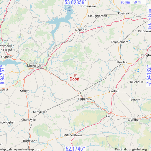
Doon GPS coordinates[2]
52° 36' 12.996" North, 8° 14' 39.984" West
| Map corner | latitude | longitude |
|---|---|---|
| Upper-left | 53.02856°, | -8.94757° |
| Center: | 52.60361°, | -8.24444° |
| Lower-right: | 52.1745°, | -7.54132° |
| Map W x H: | 95×95 km | = 59×59mi |
| max Lat: | 55.25° ⇑75.9% North |
| Doon: | 52.60361° |
| min Lat: | ⇓24.1% South 51.52487° |
| min Long | Doon | max Long |
| -10.26889° | -8.24444° | -6.04944° |
| W 32.3%⇐ | ⇒67.7% E |
Elevation
Elevation of Doon is 98 m = 322 ft, and this is 43.5 m = 143 ft above average elevation for this country.
| Max E: |
262 m = 860 ft | 13.9% |
| Doon | 98 m 322 ft | |
| Avg. | 54.5 m = 179 ft | |
Min E: |
0 m = 0 ft | 86.1% |
See also: Ireland elevation on elevation.city.
Geographical zone
Doon is located in North temperate zone (between Tropic of Cancer and the Arctic Circle). Distance of this North polar circle is 1552.2 km =964.5 mi to North.| Distance of | km | miles | from Doon |
|---|---|---|---|
| North Pole | 4158.1 | 2583.7 | to North |
| Arctic Circle | 1552.2 | 964.5 | to North |
| Tropic Cancer | 3243.1 | 2015.2 | to South |
| Equator | 5849 | 3634.4 | to South |


Nearby cities:
15 places around Doon: (largest is in red/bold)
• Annacotty
20.6 km =12.8 mi,  290°
290°
• Ballina
26.1 km =16.2 mi,  330°
330°
• Borrisoleigh
25.7 km =16 mi,  49°
49°
• Bruff
25 km =15.5 mi,  234°
234°
• Caherconlish
15.3 km =9.5 mi,  265°
265°
• Cappamore
6.3 km =3.9 mi,  281°
281°
• Cashel
26.1 km =16.2 mi,  111°
111°
• Castleconnell
21.1 km =13.1 mi,  305°
305°
• Clonlara
24.7 km =15.3 mi,  302°
302°
• Holycross
26.1 km =16.2 mi,  81°
81°
• Hospital
19.2 km =11.9 mi,  220°
220°
• Moroe
11.5 km =7.1 mi, 297°
• Newport
16.3 km =10.1 mi,  316°
316°
• Pallasgreen
7.5 km =4.7 mi,  237°
237°
• Tipperary
15.7 km =9.8 mi,  157°
157°
Sources, notices
• [Note1] Compared only with cities in Ireland existing in our database
• [Src1] Map data: © OpenStreetMap contributors (CC-BY-SA)
• [Src2] Other city data from geonames.org with taken over terms of usage.
• [Src3] Geographical zone / Annual Mean Temperature by Robert A. Rohde @ Wikipedia
