Tipperary geodata
Tipperary (Munster) is a populated place; located in Ireland in Europe/Dublin (GMT+1) time zone. With population of 4,976 people, there are 136 cities with bigger population in this country. Compared to other cities in Ireland, 80.3% of cities are located further ↑North; 65.1% of cities are located further →East and 81.4% of cities have lower elevation than Tipperary. Note1


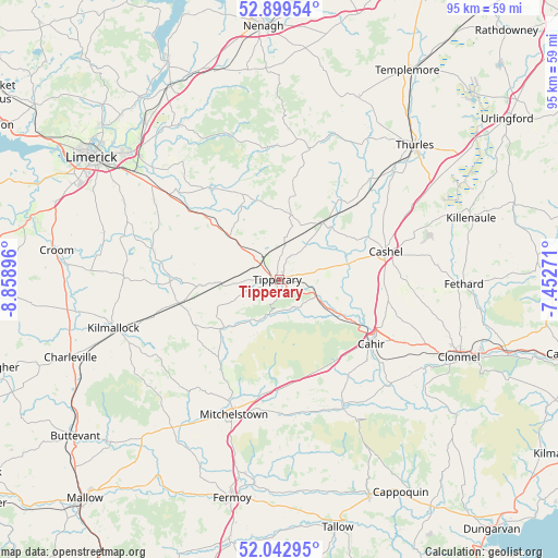
Tipperary GPS coordinates[2]
52° 28' 23.988" North, 8° 9' 20.988" West
| Map corner | latitude | longitude |
|---|---|---|
| Upper-left | 52.89954°, | -8.85896° |
| Center: | 52.47333°, | -8.15583° |
| Lower-right: | 52.04295°, | -7.45271° |
| Map W x H: | 95.2×95.2 km | = 59.2×59.2mi |
| max Lat: | 55.25° ⇑80.3% North |
| Tipperary: | 52.47333° |
| min Lat: | ⇓19.7% South 51.52487° |
| min Long | Tipperary | max Long |
| -10.26889° | -8.15583° | -6.04944° |
| W 34.9%⇐ | ⇒65.1% E |
Elevation
Elevation of Tipperary is 91 m = 299 ft, and this is 36.5 m = 120 ft above average elevation for this country.
| Max E: |
262 m = 860 ft | 18.6% |
| Tipperary | 91 m 299 ft | |
| Avg. | 54.5 m = 179 ft | |
Min E: |
0 m = 0 ft | 81.4% |
See also: Ireland elevation on elevation.city.
Geographical zone
Tipperary is located in North temperate zone (between Tropic of Cancer and the Arctic Circle). Distance of this North polar circle is 1566.7 km =973.5 mi to North.| Distance of | km | miles | from Tipperary |
|---|---|---|---|
| North Pole | 4172.6 | 2592.7 | to North |
| Arctic Circle | 1566.7 | 973.5 | to North |
| Tropic Cancer | 3228.6 | 2006.2 | to South |
| Equator | 5834.5 | 3625.4 | to South |


Nearby cities:
15 places around Tipperary: (largest is in red/bold)
• Ardfinnan
26.2 km =16.3 mi,  133°
133°
• Ballyclerahan
27.9 km =17.3 mi,  104°
104°
• Bruff
26.4 km =16.4 mi,  270°
270°
• Caherconlish
25.1 km =15.6 mi,  302°
302°
• Cahir
19.2 km =11.9 mi,  124°
124°
• Cappamore
19.8 km =12.3 mi,  322°
322°
• Cashel
18.9 km =11.7 mi,  75°
75°
• Doon
15.7 km =9.8 mi,  337°
337°
• Holycross
27.1 km =16.8 mi,  46°
46°
• Hospital
18.6 km =11.6 mi, 269°
• Kilfinnane
24.7 km =15.3 mi,  239°
239°
• Kilmallock
29.7 km =18.5 mi,  254°
254°
• Mitchelstown
24.3 km =15.1 mi,  198°
198°
• Moroe
25.6 km =15.9 mi, 320°
• Pallasgreen
16.2 km =10.1 mi,  310°
310°
Sources, notices
• [Note1] Compared only with cities in Ireland existing in our database
• [Src1] Map data: © OpenStreetMap contributors (CC-BY-SA)
• [Src2] Other city data from geonames.org with taken over terms of usage.
• [Src3] Geographical zone / Annual Mean Temperature by Robert A. Rohde @ Wikipedia
