Piltown geodata
Piltown (Leinster) is a populated place; located in Ireland in Europe/Dublin (GMT+1) time zone. With population of 1,187 people, there are 315 cities with bigger population in this country. Compared to other cities in Ireland, 83.9% of cities are located further ↑North; 51% of cities are located further ←West and 65.3% of cities have higher elevation than Piltown. Note1


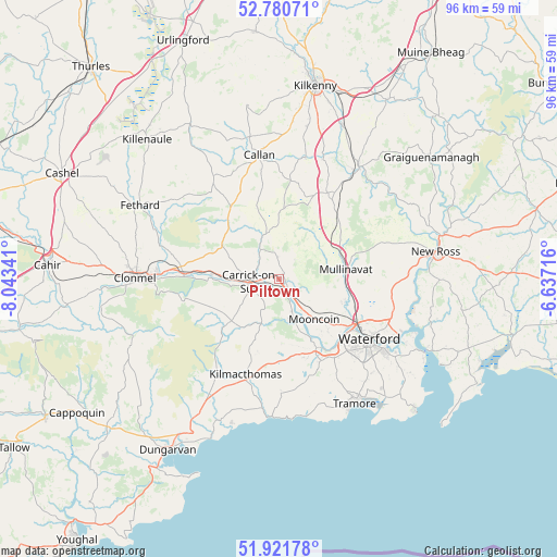
Piltown GPS coordinates[2]
52° 21' 11.988" North, 7° 20' 25.008" West
| Map corner | latitude | longitude |
|---|---|---|
| Upper-left | 52.78071°, | -8.04341° |
| Center: | 52.35333°, | -7.34028° |
| Lower-right: | 51.92178°, | -6.63716° |
| Map W x H: | 95.5×95.5 km | = 59.3×59.3mi |
| max Lat: | 55.25° ⇑83.9% North |
| Piltown: | 52.35333° |
| min Lat: | ⇓16.1% South 51.52487° |
| min Long | Piltown | max Long |
| -10.26889° | -7.34028° | -6.04944° |
| W 51%⇐ | ⇒49% E |
Elevation
Elevation of Piltown is 31 m = 102 ft, and this is 23.5 m = 77 ft below average elevation for this country.
| Max E: |
262 m = 860 ft | 65.3% |
| Avg. | 54.5 m = 179 ft | |
| Piltown | 31 m = 102 ft | |
Min E: |
0 m = 0 ft | 34.7% |
See also: Ireland elevation on elevation.city.
Geographical zone
Piltown is located in North temperate zone (between Tropic of Cancer and the Arctic Circle). Distance of this North polar circle is 1580 km =981.8 mi to North.| Distance of | km | miles | from Piltown |
|---|---|---|---|
| North Pole | 4185.9 | 2601 | to North |
| Arctic Circle | 1580 | 981.8 | to North |
| Tropic Cancer | 3215.2 | 1997.8 | to South |
| Equator | 5821.1 | 3617.1 | to South |


Nearby cities:
15 places around Piltown: (largest is in red/bold)
• Bennettsbridge
28.7 km =17.8 mi,  22°
22°
• Callan
21.6 km =13.4 mi,  350°
350°
• Carrick-on-Suir
5 km =3.1 mi,  264°
264°
• Cluain Meala
24.7 km =15.3 mi,  270°
270°
• Fethard
27 km =16.8 mi,  298°
298°
• Kilmacow
11.8 km =7.3 mi,  109°
109°
• Kilmacthomas
17.4 km =10.8 mi,  199°
199°
• Kilsheelan
16.1 km =10 mi, 272°
• Mooncoin
9.5 km =5.9 mi,  138°
138°
• New Ross
27.8 km =17.3 mi,  80°
80°
• Passage East
28.4 km =17.6 mi,  118°
118°
• Portlaw
7.4 km =4.6 mi,  169°
169°
• Thomastown
23.7 km =14.7 mi,  35°
35°
• Trá Mhór
24.8 km =15.4 mi,  148°
148°
• Waterford
18.8 km =11.7 mi, 124°
Sources, notices
• [Note1] Compared only with cities in Ireland existing in our database
• [Src1] Map data: © OpenStreetMap contributors (CC-BY-SA)
• [Src2] Other city data from geonames.org with taken over terms of usage.
• [Src3] Geographical zone / Annual Mean Temperature by Robert A. Rohde @ Wikipedia
