Ballyhaise geodata
Ballyhaise (Ulster) is a populated place; located in Ireland in Europe/Dublin (GMT+1) time zone. With population of 620 people, there are 472 cities with bigger population in this country. Compared to other cities in Ireland, 88.4% of cities are located further ↓South; 52% of cities are located further ←West and 84.6% of cities have lower elevation than Ballyhaise. Note1


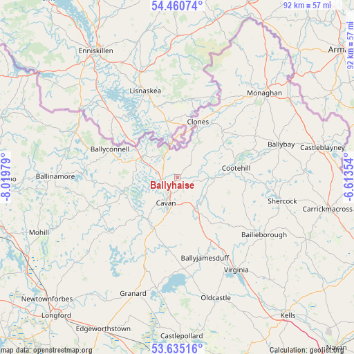
Ballyhaise GPS coordinates[2]
54° 3' 0" North, 7° 19' 0.012" West
| Map corner | latitude | longitude |
|---|---|---|
| Upper-left | 54.46074°, | -8.01979° |
| Center: | 54.05°, | -7.31667° |
| Lower-right: | 53.63516°, | -6.61354° |
| Map W x H: | 91.8×91.8 km | = 57×57mi |
| max Lat: | 55.25° ⇑11.6% North |
| Ballyhaise: | 54.05° |
| min Lat: | ⇓88.4% South 51.52487° |
| min Long | Ballyhaise | max Long |
| -10.26889° | -7.31667° | -6.04944° |
| W 52%⇐ | ⇒48% E |
Elevation
Elevation of Ballyhaise is 95 m = 312 ft, and this is 40.5 m = 133 ft above average elevation for this country.
| Max E: |
262 m = 860 ft | 15.4% |
| Ballyhaise | 95 m 312 ft | |
| Avg. | 54.5 m = 179 ft | |
Min E: |
0 m = 0 ft | 84.6% |
See also: Ireland elevation on elevation.city.
Geographical zone
Ballyhaise is located in North temperate zone (between Tropic of Cancer and the Arctic Circle). Distance of this North polar circle is 1391.4 km =864.6 mi to North.| Distance of | km | miles | from Ballyhaise |
|---|---|---|---|
| North Pole | 3997.3 | 2483.8 | to North |
| Arctic Circle | 1391.4 | 864.6 | to North |
| Tropic Cancer | 3403.9 | 2115.1 | to South |
| Equator | 6009.8 | 3734.3 | to South |


Nearby cities:
15 places around Ballyhaise: (largest is in red/bold)
• Bailieborough
27.3 km =17 mi,  122°
122°
• Ballinagh
14.5 km =9 mi,  206°
206°
• Ballinamore
31.6 km =19.6 mi,  270°
270°
• Ballyconnell
18.9 km =11.7 mi,  293°
293°
• Ballyjamesduff
21.8 km =13.5 mi,  160°
160°
• Belturbet
10.3 km =6.4 mi,  302°
302°
• Cavan
7.2 km =4.5 mi,  203°
203°
• Clones
15.8 km =9.8 mi,  20°
20°
• Cootehill
15.5 km =9.6 mi,  80°
80°
• Granard
32.3 km =20.1 mi, 201°
• Monaghan
31.8 km =19.8 mi,  45°
45°
• Mullagh
35.6 km =22.1 mi,  137°
137°
• Oldcastle
33.1 km =20.6 mi, 162°
• Shercock
27.8 km =17.3 mi,  101°
101°
• Virginia
28.7 km =17.8 mi,  146°
146°
Sources, notices
• [Note1] Compared only with cities in Ireland existing in our database
• [Src1] Map data: © OpenStreetMap contributors (CC-BY-SA)
• [Src2] Other city data from geonames.org with taken over terms of usage.
• [Src3] Geographical zone / Annual Mean Temperature by Robert A. Rohde @ Wikipedia
