Cavan geodata
Cavan (Ulster) is a seat of a second-order administrative division; located in Ireland in Europe/Dublin (GMT+1) time zone. With population of 6,388 people, there are 107 cities with bigger population in this country. Compared to other cities in Ireland, 87.7% of cities are located further ↓South; 50.7% of cities are located further ←West and 66% of cities have lower elevation than Cavan. Note1


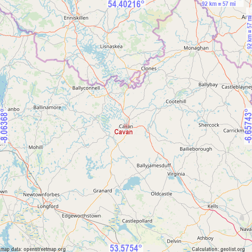
Cavan GPS coordinates[2]
53° 59' 26.988" North, 7° 21' 38.016" West
| Map corner | latitude | longitude |
|---|---|---|
| Upper-left | 54.40216°, | -8.06368° |
| Center: | 53.99083°, | -7.36056° |
| Lower-right: | 53.5754°, | -6.65743° |
| Map W x H: | 91.9×91.9 km | = 57.1×57.1mi |
| max Lat: | 55.25° ⇑12.3% North |
| Cavan: | 53.99083° |
| min Lat: | ⇓87.7% South 51.52487° |
| min Long | Cavan | max Long |
| -10.26889° | -7.36056° | -6.04944° |
| W 50.7%⇐ | ⇒49.3% E |
Elevation
Elevation of Cavan is 65 m = 213 ft, and this is 10.5 m = 34 ft above average elevation for this country.
| Max E: |
262 m = 860 ft | 34% |
| Cavan | 65 m 213 ft | |
| Avg. | 54.5 m = 179 ft | |
Min E: |
0 m = 0 ft | 66% |
See also: Ireland elevation on elevation.city.
Geographical zone
Cavan is located in North temperate zone (between Tropic of Cancer and the Arctic Circle). Distance of this North polar circle is 1398 km =868.7 mi to North.| Distance of | km | miles | from Cavan |
|---|---|---|---|
| North Pole | 4003.8 | 2487.8 | to North |
| Arctic Circle | 1398 | 868.7 | to North |
| Tropic Cancer | 3397.3 | 2111 | to South |
| Equator | 6003.2 | 3730.2 | to South |


Nearby cities:
15 places around Cavan: (largest is in red/bold)
• Bailieborough
27.1 km =16.8 mi,  107°
107°
• Ballinagh
7.4 km =4.6 mi,  209°
209°
• Ballinamore
29.5 km =18.3 mi,  282°
282°
• Ballyconnell
20.2 km =12.6 mi,  313°
313°
• Ballyhaise
7.2 km =4.5 mi,  23°
23°
• Ballyjamesduff
17.4 km =10.8 mi,  143°
143°
• Belturbet
13.5 km =8.4 mi,  334°
334°
• Clones
23 km =14.3 mi, 21°
• Cootehill
20.3 km =12.6 mi,  63°
63°
• Drumlish
32.9 km =20.4 mi,  233°
233°
• Granard
25.1 km =15.6 mi,  200°
200°
• Mullagh
33.3 km =20.7 mi,  126°
126°
• Oldcastle
28.1 km =17.5 mi,  152°
152°
• Shercock
30.1 km =18.7 mi,  88°
88°
• Virginia
25.6 km =15.9 mi, 133°
Sources, notices
• [Note1] Compared only with cities in Ireland existing in our database
• [Src1] Map data: © OpenStreetMap contributors (CC-BY-SA)
• [Src2] Other city data from geonames.org with taken over terms of usage.
• [Src3] Geographical zone / Annual Mean Temperature by Robert A. Rohde @ Wikipedia
