Eadestown geodata
Eadestown (Leinster) is a populated place; located in Ireland in Europe/Dublin (GMT+1) time zone. With population of 5,346 people, there are 128 cities with bigger population in this country. Compared to other cities in Ireland, 53.1% of cities are located further ↑North; 71.3% of cities are located further ←West and 98.7% of cities have lower elevation than Eadestown. Note1


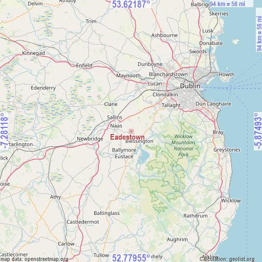
Eadestown GPS coordinates[2]
53° 12' 10.008" North, 6° 34' 41.016" West
| Map corner | latitude | longitude |
|---|---|---|
| Upper-left | 53.62187°, | -7.28118° |
| Center: | 53.20278°, | -6.57806° |
| Lower-right: | 52.77955°, | -5.87493° |
| Map W x H: | 93.7×93.7 km | = 58.2×58.2mi |
| max Lat: | 55.25° ⇑53.1% North |
| Eadestown: | 53.20278° |
| min Lat: | ⇓46.9% South 51.52487° |
| min Long | Eadestown | max Long |
| -10.26889° | -6.57806° | -6.04944° |
| W 71.3%⇐ | ⇒28.7% E |
Elevation
Elevation of Eadestown is 175 m = 574 ft, and this is 120.5 m = 395 ft above average elevation for this country.
| Max E: |
262 m = 860 ft | 1.3% |
| Eadestown | 175 m 574 ft | |
| Avg. | 54.5 m = 179 ft | |
Min E: |
0 m = 0 ft | 98.7% |
See also: Ireland elevation on elevation.city.
Geographical zone
Eadestown is located in North temperate zone (between Tropic of Cancer and the Arctic Circle). Distance of this North polar circle is 1485.6 km =923.1 mi to North.| Distance of | km | miles | from Eadestown |
|---|---|---|---|
| North Pole | 4091.5 | 2542.3 | to North |
| Arctic Circle | 1485.6 | 923.1 | to North |
| Tropic Cancer | 3309.7 | 2056.6 | to South |
| Equator | 5915.6 | 3675.8 | to South |


Nearby cities:
15 places around Eadestown: (largest is in red/bold)
• Ballymore Eustace
8.1 km =5 mi,  198°
198°
• Blessington
4.7 km =2.9 mi,  140°
140°
• Carragh
10.7 km =6.6 mi,  290°
290°
• Clane
12.3 km =7.6 mi,  323°
323°
• Jobstown
14.1 km =8.8 mi,  53°
53°
• Johnstown
4.9 km =3 mi, 323°
• Kilcullen
13.7 km =8.5 mi,  233°
233°
• Kill
5.5 km =3.4 mi,  350°
350°
• Naas
6.1 km =3.8 mi,  283°
283°
• Newcastle
12 km =7.5 mi,  24°
24°
• Rathcoole
11.3 km =7 mi,  38°
38°
• Saggart
12.4 km =7.7 mi, 45°
• Sallins
7.8 km =4.8 mi,  311°
311°
• Straffan
12.6 km =7.8 mi, 349°
• Valleymount
11.1 km =6.9 mi,  171°
171°
Sources, notices
• [Note1] Compared only with cities in Ireland existing in our database
• [Src1] Map data: © OpenStreetMap contributors (CC-BY-SA)
• [Src2] Other city data from geonames.org with taken over terms of usage.
• [Src3] Geographical zone / Annual Mean Temperature by Robert A. Rohde @ Wikipedia
