Rathcoole geodata
Rathcoole (Leinster) is a populated place; located in Ireland in Europe/Dublin (GMT+1) time zone. With population of 3,421 people, there are 176 cities with bigger population in this country. Compared to other cities in Ireland, 53.3% of cities are located further ↓South; 75.3% of cities are located further ←West and 93% of cities have lower elevation than Rathcoole. Note1


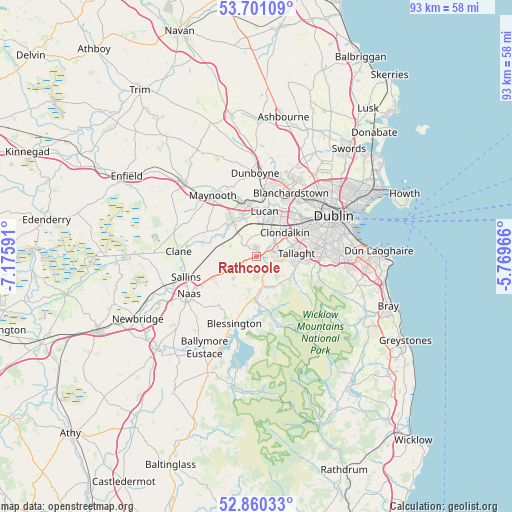
Rathcoole GPS coordinates[2]
53° 16' 58.008" North, 6° 28' 22.008" West
| Map corner | latitude | longitude |
|---|---|---|
| Upper-left | 53.70109°, | -7.17591° |
| Center: | 53.28278°, | -6.47278° |
| Lower-right: | 52.86033°, | -5.76966° |
| Map W x H: | 93.5×93.5 km | = 58.1×58.1mi |
| max Lat: | 55.25° ⇑46.7% North |
| Rathcoole: | 53.28278° |
| min Lat: | ⇓53.3% South 51.52487° |
| min Long | Rathcoole | max Long |
| -10.26889° | -6.47278° | -6.04944° |
| W 75.3%⇐ | ⇒24.7% E |
Elevation
Elevation of Rathcoole is 114 m = 374 ft, and this is 59.5 m = 195 ft above average elevation for this country.
| Max E: |
262 m = 860 ft | 7% |
| Rathcoole | 114 m 374 ft | |
| Avg. | 54.5 m = 179 ft | |
Min E: |
0 m = 0 ft | 93% |
See also: Ireland elevation on elevation.city.
Geographical zone
Rathcoole is located in North temperate zone (between Tropic of Cancer and the Arctic Circle). Distance of this North polar circle is 1476.7 km =917.6 mi to North.| Distance of | km | miles | from Rathcoole |
|---|---|---|---|
| North Pole | 4082.6 | 2536.8 | to North |
| Arctic Circle | 1476.7 | 917.6 | to North |
| Tropic Cancer | 3318.6 | 2062.1 | to South |
| Equator | 5924.5 | 3681.3 | to South |


Nearby cities:
15 places around Rathcoole: (largest is in red/bold)
• Celbridge
8.1 km =5 mi,  324°
324°
• Cherry Orchard
8.6 km =5.3 mi,  46°
46°
• Clondalkin
6.8 km =4.2 mi, 47°
• Firhouse
8.9 km =5.5 mi,  90°
90°
• Jobstown
4.3 km =2.7 mi,  96°
96°
• Kill
8.6 km =5.3 mi,  246°
246°
• Knocklyon
9.4 km =5.8 mi, 91°
• Leixlip
9.4 km =5.8 mi,  350°
350°
• Lucan
8.4 km =5.2 mi,  10°
10°
• Newcastle
2.8 km =1.7 mi, 316°
• Oldbawn
7 km =4.3 mi, 96°
• Palmerstown
9.8 km =6.1 mi,  40°
40°
• Saggart
1.9 km =1.2 mi, 98°
• Straffan
10 km =6.2 mi,  290°
290°
• Tallaght
6.6 km =4.1 mi, 86°
Sources, notices
• [Note1] Compared only with cities in Ireland existing in our database
• [Src1] Map data: © OpenStreetMap contributors (CC-BY-SA)
• [Src2] Other city data from geonames.org with taken over terms of usage.
• [Src3] Geographical zone / Annual Mean Temperature by Robert A. Rohde @ Wikipedia
