Newcastle geodata
Newcastle (Leinster) is a populated place; located in Ireland in Europe/Dublin (GMT+1) time zone. With population of 2,659 people, there are 198 cities with bigger population in this country. Compared to other cities in Ireland, 55.8% of cities are located further ↓South; 73.6% of cities are located further ←West and 79.1% of cities have lower elevation than Newcastle. Note1


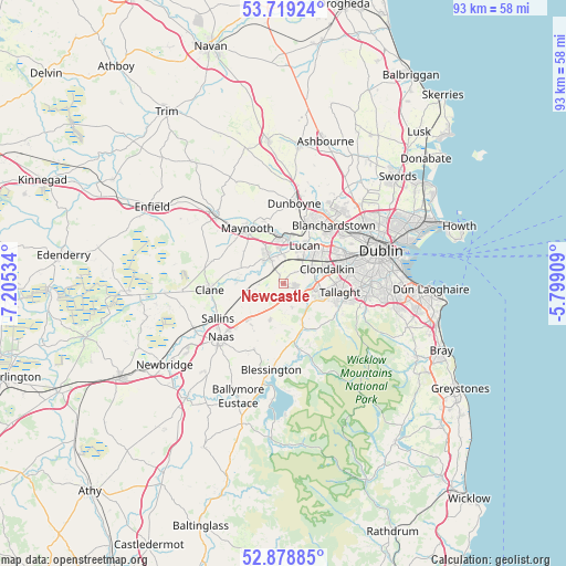
Newcastle GPS coordinates[2]
53° 18' 3.996" North, 6° 30' 7.992" West
| Map corner | latitude | longitude |
|---|---|---|
| Upper-left | 53.71924°, | -7.20534° |
| Center: | 53.30111°, | -6.50222° |
| Lower-right: | 52.87885°, | -5.79909° |
| Map W x H: | 93.4×93.4 km | = 58×58mi |
| max Lat: | 55.25° ⇑44.2% North |
| Newcastle: | 53.30111° |
| min Lat: | ⇓55.8% South 51.52487° |
| min Long | Newcastle | max Long |
| -10.26889° | -6.50222° | -6.04944° |
| W 73.6%⇐ | ⇒26.4% E |
Elevation
Elevation of Newcastle is 87 m = 285 ft, and this is 32.5 m = 107 ft above average elevation for this country.
| Max E: |
262 m = 860 ft | 20.9% |
| Newcastle | 87 m 285 ft | |
| Avg. | 54.5 m = 179 ft | |
Min E: |
0 m = 0 ft | 79.1% |
See also: Ireland elevation on elevation.city.
Geographical zone
Newcastle is located in North temperate zone (between Tropic of Cancer and the Arctic Circle). Distance of this North polar circle is 1474.6 km =916.3 mi to North.| Distance of | km | miles | from Newcastle |
|---|---|---|---|
| North Pole | 4080.5 | 2535.5 | to North |
| Arctic Circle | 1474.6 | 916.3 | to North |
| Tropic Cancer | 3320.6 | 2063.3 | to South |
| Equator | 5926.5 | 3682.6 | to South |


Nearby cities:
15 places around Newcastle: (largest is in red/bold)
• Celbridge
5.3 km =3.3 mi,  328°
328°
• Cherry Orchard
9.1 km =5.7 mi,  64°
64°
• Clondalkin
7.4 km =4.6 mi,  69°
69°
• Confey
8.7 km =5.4 mi,  5°
5°
• Jobstown
6.7 km =4.2 mi,  111°
111°
• Johnstown
10.6 km =6.6 mi,  228°
228°
• Kill
8.1 km =5 mi, 227°
• Leixlip
7.2 km =4.5 mi,  3°
3°
• Lucan
7.2 km =4.5 mi,  29°
29°
• Oldbawn
9.4 km =5.8 mi, 107°
• Palmerstown
9.9 km =6.2 mi, 56°
• Rathcoole
2.8 km =1.7 mi,  136°
136°
• Saggart
4.5 km =2.8 mi,  121°
121°
• Straffan
7.5 km =4.7 mi,  280°
280°
• Tallaght
8.7 km =5.4 mi,  101°
101°
Sources, notices
• [Note1] Compared only with cities in Ireland existing in our database
• [Src1] Map data: © OpenStreetMap contributors (CC-BY-SA)
• [Src2] Other city data from geonames.org with taken over terms of usage.
• [Src3] Geographical zone / Annual Mean Temperature by Robert A. Rohde @ Wikipedia
