Blessington geodata
Blessington (Leinster) is a populated place; located in Ireland in Europe/Dublin (GMT+1) time zone. With population of 5,010 people, there are 135 cities with bigger population in this country. Compared to other cities in Ireland, 54.3% of cities are located further ↑North; 73.2% of cities are located further ←West and 99.6% of cities have lower elevation than Blessington. Note1


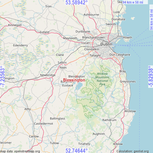
Blessington GPS coordinates[2]
53° 10' 12" North, 6° 31' 57" West
| Map corner | latitude | longitude |
|---|---|---|
| Upper-left | 53.58942°, | -7.23563° |
| Center: | 53.17°, | -6.5325° |
| Lower-right: | 52.74644°, | -5.82938° |
| Map W x H: | 93.7×93.7 km | = 58.2×58.2mi |
| max Lat: | 55.25° ⇑54.3% North |
| Blessington: | 53.17° |
| min Lat: | ⇓45.7% South 51.52487° |
| min Long | Blessington | max Long |
| -10.26889° | -6.5325° | -6.04944° |
| W 73.2%⇐ | ⇒26.8% E |
Elevation
Elevation of Blessington is 207 m = 679 ft, and this is 152.5 m = 500 ft above average elevation for this country.
| Max E: |
262 m = 860 ft | 0.40000000000001% |
| Blessington | 207 m 679 ft | |
| Avg. | 54.5 m = 179 ft | |
Min E: |
0 m = 0 ft | 99.6% |
See also: Ireland elevation on elevation.city.
Geographical zone
Blessington is located in North temperate zone (between Tropic of Cancer and the Arctic Circle). Distance of this North polar circle is 1489.2 km =925.3 mi to North.| Distance of | km | miles | from Blessington |
|---|---|---|---|
| North Pole | 4095.1 | 2544.6 | to North |
| Arctic Circle | 1489.2 | 925.3 | to North |
| Tropic Cancer | 3306 | 2054.3 | to South |
| Equator | 5911.9 | 3673.5 | to South |


Nearby cities:
15 places around Blessington: (largest is in red/bold)
• Ballymore Eustace
6.9 km =4.3 mi,  234°
234°
• Carragh
15 km =9.3 mi,  299°
299°
• Eadestown
4.7 km =2.9 mi,  320°
320°
• Jobstown
14.7 km =9.1 mi,  34°
34°
• Johnstown
9.7 km =6 mi, 321°
• Kilcullen
14.8 km =9.2 mi,  252°
252°
• Kill
9.9 km =6.2 mi,  336°
336°
• Naas
10.3 km =6.4 mi, 299°
• Newcastle
14.7 km =9.1 mi,  7°
7°
• Oldbawn
16.1 km =10 mi,  43°
43°
• Rathcoole
13.2 km =8.2 mi,  17°
17°
• Saggart
13.6 km =8.5 mi, 25°
• Sallins
12.5 km =7.8 mi,  314°
314°
• Tallaght
16.7 km =10.4 mi, 39°
• Valleymount
7.5 km =4.7 mi,  190°
190°
Sources, notices
• [Note1] Compared only with cities in Ireland existing in our database
• [Src1] Map data: © OpenStreetMap contributors (CC-BY-SA)
• [Src2] Other city data from geonames.org with taken over terms of usage.
• [Src3] Geographical zone / Annual Mean Temperature by Robert A. Rohde @ Wikipedia
