Caesarea geodata
Caesarea (Haifa) is a populated place; located in Israel in Asia/Jerusalem (GMT+3) time zone. With population of 4,500 people, there are 114 cities with bigger population in this country. Compared to other cities in Israel, 58% of cities are located further ↓South; 71% of cities are located further →East and 92.3% of cities have higher elevation than Caesarea. Note1


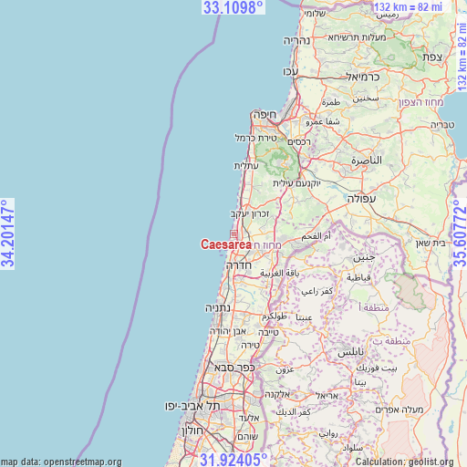
Caesarea GPS coordinates[2]
32° 31' 7.968" North, 34° 54' 16.524" East
| Map corner | latitude | longitude |
|---|---|---|
| Upper-left | 33.1098°, | 34.20147° |
| Center: | 32.51888°, | 34.90459° |
| Lower-right: | 31.92405°, | 35.60772° |
| Map W x H: | 131.8×131.8 km | = 81.9×81.9mi |
| max Lat: | 33.27918° ⇑42% North |
| Caesarea: | 32.51888° |
| min Lat: | ⇓58% South 29.55805° |
| min Long | Caesarea | max Long |
| 34.57149° | 34.90459° | 35.81084° |
| W 29%⇐ | ⇒71% E |
Elevation
Elevation of Caesarea is 16 m = 52 ft, and this is 207.4 m = 680 ft below average elevation for this country.
| Max E: |
988 m = 3241 ft | 92.3% |
| Avg. | 223.4 m = 733 ft | |
| Caesarea | 16 m = 52 ft | |
Min E: |
-380 m = -1247 ft | 7.7% |
See also: Israel elevation on elevation.city.
Geographical zone
Caesarea is located in North temperate zone (between Tropic of Cancer and the Arctic Circle). Distance of this Northern Tropic circle is 1009.8 km =627.5 mi to South.| Distance of | km | miles | from Caesarea |
|---|---|---|---|
| North Pole | 6391.3 | 3971.4 | to North |
| Arctic Circle | 3785.4 | 2352.1 | to North |
| Tropic Cancer | 1009.8 | 627.5 | to South |
| Equator | 3615.8 | 2246.8 | to South |


Nearby cities:
15 places around Caesarea: (largest is in red/bold)
• Atlit
19.2 km =11.9 mi,  10°
10°
• Bet Yiẕẖaq
21.3 km =13.2 mi,  183°
183°
• Daliyat al Karmel
23.6 km =14.7 mi,  34°
34°
• El Fureidīs
9.8 km =6.1 mi, 26°
• Elyakhin
12.5 km =7.8 mi,  171°
171°
• Even Yehuda
27.8 km =17.3 mi, 183°
• Hadera
8.6 km =5.3 mi, 180°
• Kefar Yona
22.7 km =14.1 mi, 172°
• Netanya
21.1 km =13.1 mi,  191°
191°
• Nordiyya
22.7 km =14.1 mi, 181°
• Pardesiyya
23.7 km =14.7 mi, 178°
• Qalansuwa
27 km =16.8 mi,  164°
164°
• Tirat Karmel
27.6 km =17.1 mi, 13°
• Umm el Faḥm
23.3 km =14.5 mi,  90°
90°
• Ẕur Moshe
24.6 km =15.3 mi, 178°
Sources, notices
• [Note1] Compared only with cities in Israel existing in our database
• [Src1] Map data: © OpenStreetMap contributors (CC-BY-SA)
• [Src2] Other city data from geonames.org with taken over terms of usage.
• [Src3] Geographical zone / Annual Mean Temperature by Robert A. Rohde @ Wikipedia
