El Fureidīs geodata
El Fureidīs (Haifa) is a populated place; located in Israel in Asia/Jerusalem (GMT+3) time zone. With population of 9,999 people, there are 87 cities with bigger population in this country. Compared to other cities in Israel, 58.6% of cities are located further ↓South; 63.3% of cities are located further →East and 86.4% of cities have higher elevation than El Fureidīs. Note1


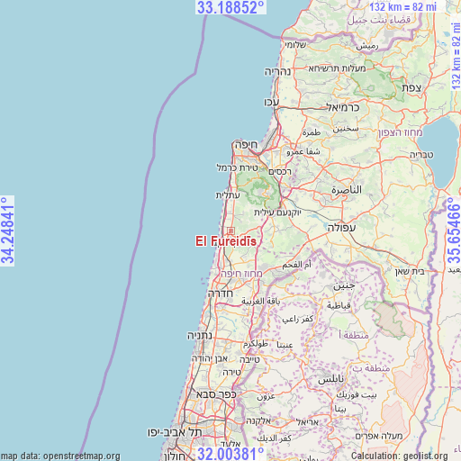
El Fureidīs GPS coordinates[2]
32° 35' 53.232" North, 34° 57' 5.508" East
| Map corner | latitude | longitude |
|---|---|---|
| Upper-left | 33.18852°, | 34.24841° |
| Center: | 32.59812°, | 34.95153° |
| Lower-right: | 32.00381°, | 35.65466° |
| Map W x H: | 131.7×131.7 km | = 81.8×81.8mi |
| max Lat: | 33.27918° ⇑41.4% North |
| El Fureidīs: | 32.59812° |
| min Lat: | ⇓58.6% South 29.55805° |
| min Long | El Fureidīs | max Long |
| 34.57149° | 34.95153° | 35.81084° |
| W 36.7%⇐ | ⇒63.3% E |
Elevation
Elevation of El Fureidīs is 33 m = 108 ft, and this is 190.4 m = 625 ft below average elevation for this country.
| Max E: |
988 m = 3241 ft | 86.4% |
| Avg. | 223.4 m = 733 ft | |
| El Fureidīs | 33 m = 108 ft | |
Min E: |
-380 m = -1247 ft | 13.6% |
See also: Israel elevation on elevation.city.
Geographical zone
El Fureidīs is located in North temperate zone (between Tropic of Cancer and the Arctic Circle). Distance of this Northern Tropic circle is 1018.7 km =633 mi to South.| Distance of | km | miles | from El Fureidīs |
|---|---|---|---|
| North Pole | 6382.5 | 3965.9 | to North |
| Arctic Circle | 3776.6 | 2346.7 | to North |
| Tropic Cancer | 1018.7 | 633 | to South |
| Equator | 3624.6 | 2252.2 | to South |


Nearby cities:
15 places around El Fureidīs: (largest is in red/bold)
• Atlit
10.1 km =6.3 mi,  355°
355°
• Basmat Ṭab‘ūn
24.8 km =15.4 mi,  50°
50°
• Caesarea
9.8 km =6.1 mi,  206°
206°
• Daliyat al Karmel
13.9 km =8.6 mi,  39°
39°
• Elyakhin
21.3 km =13.2 mi,  186°
186°
• Hadera
17.9 km =11.1 mi, 194°
• Haifa
24.7 km =15.3 mi,  8°
8°
• Ibṭīn
23.7 km =14.7 mi, 39°
• Nesher
20.6 km =12.8 mi,  24°
24°
• Qiryat Ata
28.1 km =17.5 mi,  32°
32°
• Ramat Yishay
23.7 km =14.7 mi,  60°
60°
• Rekhasim
21.7 km =13.5 mi, 39°
• Timrat
28 km =17.4 mi,  65°
65°
• Tirat Karmel
18.1 km =11.2 mi, 6°
• Umm el Faḥm
21 km =13 mi,  115°
115°
Sources, notices
• [Note1] Compared only with cities in Israel existing in our database
• [Src1] Map data: © OpenStreetMap contributors (CC-BY-SA)
• [Src2] Other city data from geonames.org with taken over terms of usage.
• [Src3] Geographical zone / Annual Mean Temperature by Robert A. Rohde @ Wikipedia
