Netanya geodata
Netanya (Central District) is a populated place; located in Israel in Asia/Jerusalem (GMT+3) time zone. With population of 171,676 people, there are 8 cities with bigger population in this country. Compared to other cities in Israel, 55% of cities are located further ↓South; 79.3% of cities are located further →East and 82.2% of cities have higher elevation than Netanya. Note1


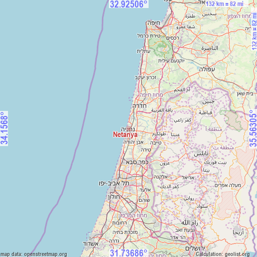
Netanya GPS coordinates[2]
32° 19' 58.476" North, 34° 51' 35.712" East
| Map corner | latitude | longitude |
|---|---|---|
| Upper-left | 32.92506°, | 34.1568° |
| Center: | 32.33291°, | 34.85992° |
| Lower-right: | 31.73686°, | 35.56305° |
| Map W x H: | 132.1×132.1 km | = 82.1×82.1mi |
| max Lat: | 33.27918° ⇑45% North |
| Netanya: | 32.33291° |
| min Lat: | ⇓55% South 29.55805° |
| min Long | Netanya | max Long |
| 34.57149° | 34.85992° | 35.81084° |
| W 20.7%⇐ | ⇒79.3% E |
Elevation
Elevation of Netanya is 38 m = 125 ft, and this is 185.4 m = 608 ft below average elevation for this country.
| Max E: |
988 m = 3241 ft | 82.2% |
| Avg. | 223.4 m = 733 ft | |
| Netanya | 38 m = 125 ft | |
Min E: |
-380 m = -1247 ft | 17.8% |
See also: Netanya elevation on elevation.city.
Geographical zone
Netanya is located in North temperate zone (between Tropic of Cancer and the Arctic Circle). Distance of this Northern Tropic circle is 989.2 km =614.7 mi to South.| Distance of | km | miles | from Netanya |
|---|---|---|---|
| North Pole | 6412 | 3984.2 | to North |
| Arctic Circle | 3806.1 | 2365 | to North |
| Tropic Cancer | 989.2 | 614.7 | to South |
| Equator | 3595.1 | 2233.9 | to South |


Nearby cities:
15 places around Netanya: (largest is in red/bold)
• Bet Yiẕẖaq
2.8 km =1.7 mi,  102°
102°
• Elyakhin
10.3 km =6.4 mi,  35°
35°
• Even Yehuda
7.5 km =4.7 mi,  159°
159°
• Eṭ Ṭaiyiba
15.8 km =9.8 mi,  117°
117°
• Hadera
12.8 km =8 mi,  18°
18°
• Kefar Shemaryahu
16.8 km =10.4 mi,  192°
192°
• Kefar Yona
7.3 km =4.5 mi, 104°
• Kfar Saba
18.1 km =11.2 mi,  165°
165°
• Nordiyya
4 km =2.5 mi, 120°
• Pardesiyya
5.5 km =3.4 mi, 123°
• Qalansuwa
12.6 km =7.8 mi, 115°
• Ra'anana
16.7 km =10.4 mi,  175°
175°
• Tel Mond
10.7 km =6.6 mi,  149°
149°
• Tirah
13.9 km =8.6 mi,  142°
142°
• Ẕur Moshe
6.3 km =3.9 mi,  127°
127°
Sources, notices
• [Note1] Compared only with cities in Israel existing in our database
• [Src1] Map data: © OpenStreetMap contributors (CC-BY-SA)
• [Src2] Other city data from geonames.org with taken over terms of usage.
• [Src3] Geographical zone / Annual Mean Temperature by Robert A. Rohde @ Wikipedia
