Elyakhin geodata
Elyakhin (Central District) is a populated place; located in Israel in Asia/Jerusalem (GMT+3) time zone. With population of 2,728 people, there are 126 cities with bigger population in this country. Compared to other cities in Israel, 55.6% of cities are located further ↓South; 67.5% of cities are located further →East and 84.6% of cities have higher elevation than Elyakhin. Note1


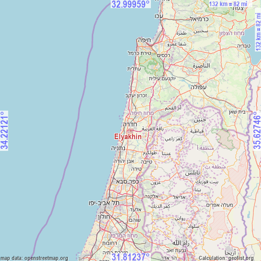
Elyakhin GPS coordinates[2]
32° 24' 28.548" North, 34° 55' 27.588" East
| Map corner | latitude | longitude |
|---|---|---|
| Upper-left | 32.99959°, | 34.22121° |
| Center: | 32.40793°, | 34.92433° |
| Lower-right: | 31.81237°, | 35.62746° |
| Map W x H: | 132×132 km | = 82×82mi |
| max Lat: | 33.27918° ⇑44.4% North |
| Elyakhin: | 32.40793° |
| min Lat: | ⇓55.6% South 29.55805° |
| min Long | Elyakhin | max Long |
| 34.57149° | 34.92433° | 35.81084° |
| W 32.5%⇐ | ⇒67.5% E |
Elevation
Elevation of Elyakhin is 36 m = 118 ft, and this is 187.4 m = 615 ft below average elevation for this country.
| Max E: |
988 m = 3241 ft | 84.6% |
| Avg. | 223.4 m = 733 ft | |
| Elyakhin | 36 m = 118 ft | |
Min E: |
-380 m = -1247 ft | 15.4% |
See also: Israel elevation on elevation.city.
Geographical zone
Elyakhin is located in North temperate zone (between Tropic of Cancer and the Arctic Circle). Distance of this Northern Tropic circle is 997.5 km =619.8 mi to South.| Distance of | km | miles | from Elyakhin |
|---|---|---|---|
| North Pole | 6403.6 | 3979 | to North |
| Arctic Circle | 3797.8 | 2359.8 | to North |
| Tropic Cancer | 997.5 | 619.8 | to South |
| Equator | 3603.4 | 2239 | to South |


Nearby cities:
15 places around Elyakhin: (largest is in red/bold)
• Bet Yiẕẖaq
9.5 km =5.9 mi,  200°
200°
• Caesarea
12.5 km =7.8 mi,  351°
351°
• El Fureidīs
21.3 km =13.2 mi,  6°
6°
• Even Yehuda
15.8 km =9.8 mi,  192°
192°
• Eṭ Ṭaiyiba
17.7 km =11 mi,  153°
153°
• Hadera
4.2 km =2.6 mi,  333°
333°
• Kefar Yona
10.2 km =6.3 mi,  174°
174°
• Netanya
10.3 km =6.4 mi,  215°
215°
• Nordiyya
10.7 km =6.6 mi, 194°
• Pardesiyya
11.4 km =7.1 mi, 187°
• Qalansuwa
14.7 km =9.1 mi,  158°
158°
• Tel Mond
17.6 km =10.9 mi,  182°
182°
• Tirah
19.5 km =12.1 mi, 172°
• Umm el Faḥm
24.7 km =15.3 mi,  60°
60°
• Ẕur Moshe
12.2 km =7.6 mi, 184°
Sources, notices
• [Note1] Compared only with cities in Israel existing in our database
• [Src1] Map data: © OpenStreetMap contributors (CC-BY-SA)
• [Src2] Other city data from geonames.org with taken over terms of usage.
• [Src3] Geographical zone / Annual Mean Temperature by Robert A. Rohde @ Wikipedia
