Acre geodata
Acre (Northern District) is a populated place; located in Israel in Asia/Jerusalem (GMT+3) time zone. With population of 45,603 people, there are 30 cities with bigger population in this country. Compared to other cities in Israel, 86.4% of cities are located further ↓South; 50.3% of cities are located further ←West and 96.4% of cities have higher elevation than Acre. Note1


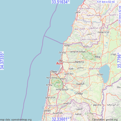
Acre GPS coordinates[2]
32° 55' 41.304" North, 35° 4' 35.292" East
| Map corner | latitude | longitude |
|---|---|---|
| Upper-left | 33.51634°, | 34.37335° |
| Center: | 32.92814°, | 35.07647° |
| Lower-right: | 32.33601°, | 35.7796° |
| Map W x H: | 131.2×131.2 km | = 81.5×81.5mi |
| max Lat: | 33.27918° ⇑13.6% North |
| Acre: | 32.92814° |
| min Lat: | ⇓86.4% South 29.55805° |
| min Long | Acre | max Long |
| 34.57149° | 35.07647° | 35.81084° |
| W 50.3%⇐ | ⇒49.7% E |
Elevation
Elevation of Acre is 8 m = 26 ft, and this is 215.4 m = 707 ft below average elevation for this country.
| Max E: |
988 m = 3241 ft | 96.4% |
| Avg. | 223.4 m = 733 ft | |
| Acre | 8 m = 26 ft | |
Min E: |
-380 m = -1247 ft | 3.6% |
See also: Acre elevation on elevation.city.
Geographical zone
Acre is located in North temperate zone (between Tropic of Cancer and the Arctic Circle). Distance of this Northern Tropic circle is 1055.3 km =655.7 mi to South.| Distance of | km | miles | from Acre |
|---|---|---|---|
| North Pole | 6345.8 | 3943.1 | to North |
| Arctic Circle | 3739.9 | 2323.9 | to North |
| Tropic Cancer | 1055.3 | 655.7 | to South |
| Equator | 3661.3 | 2275 | to South |


Nearby cities:
15 places around Acre: (largest is in red/bold)
• El Mazra‘a
6.5 km =4 mi,  18°
18°
• Esh Sheikh Dannūn
9.9 km =6.2 mi,  42°
42°
• Haifa
14.7 km =9.1 mi,  213°
213°
• Judeida Makr
7.5 km =4.7 mi,  89°
89°
• Kefar Rosh HaNiqra
17.9 km =11.1 mi,  11°
11°
• Kfar Yasif
8.5 km =5.3 mi,  69°
69°
• Kābūl
14.3 km =8.9 mi,  117°
117°
• Nahariyya
9.2 km =5.7 mi, 12°
• Nesher
18.3 km =11.4 mi,  189°
189°
• Qiryat Ata
13.4 km =8.3 mi,  165°
165°
• Qiryat Bialik
11.2 km =7 mi,  175°
175°
• Qiryat Moẕqin
10.1 km =6.3 mi, 179°
• Qiryat Yam
8.7 km =5.4 mi, 184°
• Shelomi
17.2 km =10.7 mi, 21°
• Tamra
14.1 km =8.8 mi,  126°
126°
In other languages:
- In German: Akko, Akkon
- In Italian: San Giovanni d'Acri
- In Russian: Акка
- In Chinese: 阿卡
Sources, notices
• [Note1] Compared only with cities in Israel existing in our database
• [Src1] Map data: © OpenStreetMap contributors (CC-BY-SA)
• [Src2] Other city data from geonames.org with taken over terms of usage.
• [Src3] Geographical zone / Annual Mean Temperature by Robert A. Rohde @ Wikipedia
