Pasuta geodata
Pasuta (Northern District) is a populated place; located in Israel in Asia/Jerusalem (GMT+3) time zone. With population of 2,985 people, there are 122 cities with bigger population in this country. Compared to other cities in Israel, 97% of cities are located further ↓South; 79.3% of cities are located further ←West and 90.5% of cities have lower elevation than Pasuta. Note1


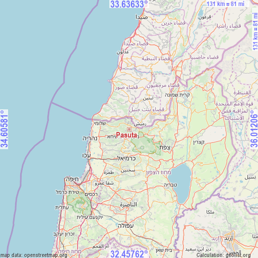
Pasuta GPS coordinates[2]
33° 2' 56.22" North, 35° 18' 32.148" East
| Map corner | latitude | longitude |
|---|---|---|
| Upper-left | 33.63633°, | 34.60581° |
| Center: | 33.04895°, | 35.30893° |
| Lower-right: | 32.45762°, | 36.01206° |
| Map W x H: | 131.1×131.1 km | = 81.5×81.5mi |
| max Lat: | 33.27918° ⇑3% North |
| Pasuta: | 33.04895° |
| min Lat: | ⇓97% South 29.55805° |
| min Long | Pasuta | max Long |
| 34.57149° | 35.30893° | 35.81084° |
| W 79.3%⇐ | ⇒20.7% E |
Elevation
Elevation of Pasuta is 639 m = 2096 ft, and this is 415.6 m = 1364 ft above average elevation for this country.
| Max E: |
988 m = 3241 ft | 9.5% |
| Pasuta | 639 m 2096 ft | |
| Avg. | 223.4 m = 733 ft | |
Min E: |
-380 m = -1247 ft | 90.5% |
See also: Israel elevation on elevation.city.
Geographical zone
Pasuta is located in North temperate zone (between Tropic of Cancer and the Arctic Circle). Distance of this Northern Tropic circle is 1068.8 km =664.1 mi to South.| Distance of | km | miles | from Pasuta |
|---|---|---|---|
| North Pole | 6332.4 | 3934.8 | to North |
| Arctic Circle | 3726.5 | 2315.5 | to North |
| Tropic Cancer | 1068.8 | 664.1 | to South |
| Equator | 3674.7 | 2283.4 | to South |


Nearby cities:
15 places around Pasuta: (largest is in red/bold)
• Beit Jann
11.6 km =7.2 mi,  144°
144°
• Buqei‘a
8.3 km =5.2 mi,  163°
163°
• Esh Sheikh Dannūn
16.2 km =10.1 mi,  247°
247°
• Jīsh
13.2 km =8.2 mi,  103°
103°
• Karmi’el
14.7 km =9.1 mi,  181°
181°
• Kefar Rosh HaNiqra
18.7 km =11.6 mi,  282°
282°
• Kefar Weradim
6.8 km =4.2 mi,  205°
205°
• Kfar Yasif
17.2 km =10.7 mi,  232°
232°
• Mi‘ilyā
5.4 km =3.4 mi,  244°
244°
• Naḥf
12.8 km =8 mi, 176°
• Sallama
18.1 km =11.2 mi, 161°
• Shelomi
15.5 km =9.6 mi, 279°
• Sājūr
12.2 km =7.6 mi,  165°
165°
• maalot Tarshīhā
5.3 km =3.3 mi, 227°
• Ḥurfeish
5.1 km =3.2 mi,  133°
133°
Sources, notices
• [Note1] Compared only with cities in Israel existing in our database
• [Src1] Map data: © OpenStreetMap contributors (CC-BY-SA)
• [Src2] Other city data from geonames.org with taken over terms of usage.
• [Src3] Geographical zone / Annual Mean Temperature by Robert A. Rohde @ Wikipedia
