maalot Tarshīhā geodata
maalot Tarshīhā (Northern District) is a populated place; located in Israel in Asia/Jerusalem (GMT+3) time zone. With population of 21,400 people, there are 62 cities with bigger population in this country. Compared to other cities in Israel, 94.7% of cities are located further ↓South; 74.6% of cities are located further ←West and 82.2% of cities have lower elevation than maalot Tarshīhā. Note1


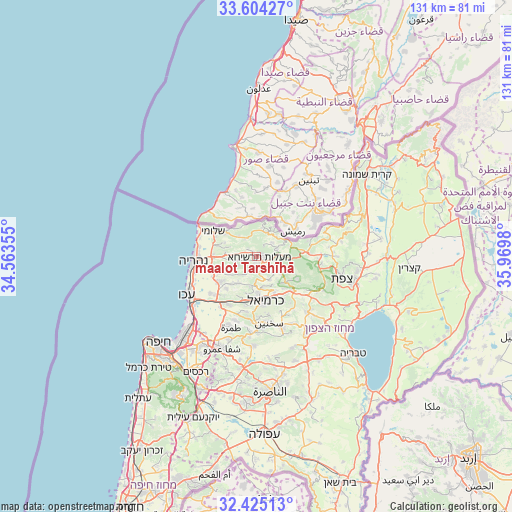
maalot Tarshīhā GPS coordinates[2]
33° 1' 0.012" North, 35° 16' 0.012" East
| Map corner | latitude | longitude |
|---|---|---|
| Upper-left | 33.60427°, | 34.56355° |
| Center: | 33.01667°, | 35.26667° |
| Lower-right: | 32.42513°, | 35.9698° |
| Map W x H: | 131.1×131.1 km | = 81.5×81.5mi |
| max Lat: | 33.27918° ⇑5.3% North |
| maalot Tarshīhā: | 33.01667° |
| min Lat: | ⇓94.7% South 29.55805° |
| min Long | maalot Tarshīh | max Long |
| 34.57149° | 35.26667° | 35.81084° |
| W 74.6%⇐ | ⇒25.4% E |
Elevation
Elevation of maalot Tarshīhā is 484 m = 1588 ft, and this is 260.6 m = 855 ft above average elevation for this country.
| Max E: |
988 m = 3241 ft | 17.8% |
| maalot Tarshīhā | 484 m 1588 ft | |
| Avg. | 223.4 m = 733 ft | |
Min E: |
-380 m = -1247 ft | 82.2% |
See also: Israel elevation on elevation.city.
Geographical zone
maalot Tarshīhā is located in North temperate zone (between Tropic of Cancer and the Arctic Circle). Distance of this Northern Tropic circle is 1065.2 km =661.9 mi to South.| Distance of | km | miles | from maalot Tarshīhā |
|---|---|---|---|
| North Pole | 6336 | 3937 | to North |
| Arctic Circle | 3730.1 | 2317.8 | to North |
| Tropic Cancer | 1065.2 | 661.9 | to South |
| Equator | 3671.1 | 2281.1 | to South |


Nearby cities:
15 places around maalot Tarshīhā: (largest is in red/bold)
• Beit Jann
12.2 km =7.6 mi,  118°
118°
• Buqei‘a
7.6 km =4.7 mi, 124°
• El Mazra‘a
16.1 km =10 mi,  256°
256°
• Esh Sheikh Dannūn
11.3 km =7 mi, 257°
• Judeida Makr
14.2 km =8.8 mi,  226°
226°
• Karmi’el
11.6 km =7.2 mi,  162°
162°
• Kefar Weradim
2.7 km =1.7 mi, 157°
• Kfar Yasif
11.9 km =7.4 mi, 234°
• Mi‘ilyā
1.6 km =1 mi,  322°
322°
• Nahariyya
15.7 km =9.8 mi,  266°
266°
• Naḥf
10.3 km =6.4 mi,  152°
152°
• Pasuta
5.3 km =3.3 mi,  47°
47°
• Shelomi
12.9 km =8 mi,  298°
298°
• Sājūr
10.8 km =6.7 mi,  139°
139°
• Ḥurfeish
7.6 km =4.7 mi,  89°
89°
Sources, notices
• [Note1] Compared only with cities in Israel existing in our database
• [Src1] Map data: © OpenStreetMap contributors (CC-BY-SA)
• [Src2] Other city data from geonames.org with taken over terms of usage.
• [Src3] Geographical zone / Annual Mean Temperature by Robert A. Rohde @ Wikipedia
