Tiberias geodata
Tiberias (Northern District) is a populated place; located in Israel in Asia/Jerusalem (GMT+3) time zone. With population of 39,790 people, there are 36 cities with bigger population in this country. Compared to other cities in Israel, 75.7% of cities are located further ↓South; 95.9% of cities are located further ←West and 98.2% of cities have higher elevation than Tiberias. Note1


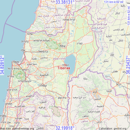
Tiberias GPS coordinates[2]
32° 47' 31.956" North, 35° 31' 52.464" East
| Map corner | latitude | longitude |
|---|---|---|
| Upper-left | 33.38131°, | 34.82812° |
| Center: | 32.79221°, | 35.53124° |
| Lower-right: | 32.19918°, | 36.23437° |
| Map W x H: | 131.4×131.4 km | = 81.6×81.6mi |
| max Lat: | 33.27918° ⇑24.3% North |
| Tiberias: | 32.79221° |
| min Lat: | ⇓75.7% South 29.55805° |
| min Long | Tiberias | max Long |
| 34.57149° | 35.53124° | 35.81084° |
| W 95.9%⇐ | ⇒4.1% E |
Elevation
Elevation of Tiberias is -140 m = -459 ft, and this is 363.4 m = 1192 ft below average elevation for this country.
| Max E: |
988 m = 3241 ft | 98.2% |
| Avg. | 223.4 m = 733 ft | |
| Tiberias | -140 m = -459 ft | |
Min E: |
-380 m = -1247 ft | 1.8% |
See also: Israel elevation on elevation.city.
Geographical zone
Tiberias is located in North temperate zone (between Tropic of Cancer and the Arctic Circle). Distance of this Northern Tropic circle is 1040.2 km =646.4 mi to South.| Distance of | km | miles | from Tiberias |
|---|---|---|---|
| North Pole | 6360.9 | 3952.5 | to North |
| Arctic Circle | 3755 | 2333.2 | to North |
| Tropic Cancer | 1040.2 | 646.4 | to South |
| Equator | 3646.2 | 2265.6 | to South |


Nearby cities:
15 places around Tiberias: (largest is in red/bold)
• Al Buţayḩah
16 km =9.9 mi,  35°
35°
• Bu‘eina
15.6 km =9.7 mi,  275°
275°
• Dabbūrīya
18.6 km =11.6 mi,  233°
233°
• Deir Ḥannā
17.5 km =10.9 mi,  296°
296°
• Fīq
15.9 km =9.9 mi,  95°
95°
• Kafr Kammā
11.5 km =7.1 mi, 226°
• Kafr Kannā
18.4 km =11.4 mi,  253°
253°
• Kafr Miṣr
19.3 km =12 mi,  212°
212°
• Kefar Tavor
15.6 km =9.7 mi,  221°
221°
• Maghār
15.9 km =9.9 mi,  313°
313°
• Sallama
18.9 km =11.7 mi, 306°
• Shibli
16.9 km =10.5 mi, 230°
• Yavne’el
9.9 km =6.2 mi,  194°
194°
• ‘Eilabun
13.2 km =8.2 mi,  292°
292°
• ‘Uzeir
18.8 km =11.7 mi,  269°
269°
In other languages:
- In Spanish: Tiberíades
- In France: Tibériade
- In Italian: Tiberiade
- In Russian: Тверия
- In Chinese: 提比里亞
Sources, notices
• [Note1] Compared only with cities in Israel existing in our database
• [Src1] Map data: © OpenStreetMap contributors (CC-BY-SA)
• [Src2] Other city data from geonames.org with taken over terms of usage.
• [Src3] Geographical zone / Annual Mean Temperature by Robert A. Rohde @ Wikipedia
