El Mazra‘a geodata
El Mazra‘a (Northern District) is a populated place; located in Israel in Asia/Jerusalem (GMT+3) time zone. With population of 3,900 people, there are 117 cities with bigger population in this country. Compared to other cities in Israel, 91.7% of cities are located further ↓South; 53.3% of cities are located further ←West and 88.8% of cities have higher elevation than El Mazra‘a. Note1


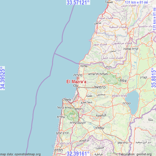
El Mazra‘a GPS coordinates[2]
32° 59' 0.168" North, 35° 5' 54.132" East
| Map corner | latitude | longitude |
|---|---|---|
| Upper-left | 33.57121°, | 34.39525° |
| Center: | 32.98338°, | 35.09837° |
| Lower-right: | 32.39161°, | 35.8015° |
| Map W x H: | 131.2×131.2 km | = 81.5×81.5mi |
| max Lat: | 33.27918° ⇑8.3% North |
| El Mazra‘a: | 32.98338° |
| min Lat: | ⇓91.7% South 29.55805° |
| min Long | El Mazra‘a | max Long |
| 34.57149° | 35.09837° | 35.81084° |
| W 53.3%⇐ | ⇒46.7% E |
Elevation
Elevation of El Mazra‘a is 28 m = 92 ft, and this is 195.4 m = 641 ft below average elevation for this country.
| Max E: |
988 m = 3241 ft | 88.8% |
| Avg. | 223.4 m = 733 ft | |
| El Mazra‘a | 28 m = 92 ft | |
Min E: |
-380 m = -1247 ft | 11.2% |
See also: Israel elevation on elevation.city.
Geographical zone
El Mazra‘a is located in North temperate zone (between Tropic of Cancer and the Arctic Circle). Distance of this Northern Tropic circle is 1061.5 km =659.6 mi to South.| Distance of | km | miles | from El Mazra‘a |
|---|---|---|---|
| North Pole | 6339.7 | 3939.3 | to North |
| Arctic Circle | 3733.8 | 2320.1 | to North |
| Tropic Cancer | 1061.5 | 659.6 | to South |
| Equator | 3667.4 | 2278.8 | to South |


Nearby cities:
15 places around El Mazra‘a: (largest is in red/bold)
• Acre
6.5 km =4 mi,  198°
198°
• Esh Sheikh Dannūn
4.8 km =3 mi,  75°
75°
• Judeida Makr
8.2 km =5.1 mi,  138°
138°
• Kefar Rosh HaNiqra
11.5 km =7.1 mi,  7°
7°
• Kefar Weradim
16.8 km =10.4 mi,  86°
86°
• Kfar Yasif
6.8 km =4.2 mi,  118°
118°
• Kābūl
16.6 km =10.3 mi, 140°
• Mi‘ilyā
15.6 km =9.7 mi,  71°
71°
• Nahariyya
2.8 km =1.7 mi,  359°
359°
• Qiryat Bialik
17.4 km =10.8 mi,  183°
183°
• Qiryat Moẕqin
16.4 km =10.2 mi,  186°
186°
• Qiryat Yam
15.1 km =9.4 mi, 190°
• Shelomi
10.8 km =6.7 mi,  23°
23°
• Tamra
17.3 km =10.7 mi,  147°
147°
• maalot Tarshīhā
16.1 km =10 mi, 76°
Sources, notices
• [Note1] Compared only with cities in Israel existing in our database
• [Src1] Map data: © OpenStreetMap contributors (CC-BY-SA)
• [Src2] Other city data from geonames.org with taken over terms of usage.
• [Src3] Geographical zone / Annual Mean Temperature by Robert A. Rohde @ Wikipedia
