Nahariyya geodata
Nahariyya (Northern District) is a populated place; located in Israel in Asia/Jerusalem (GMT+3) time zone. With population of 51,200 people, there are 26 cities with bigger population in this country. Compared to other cities in Israel, 94.1% of cities are located further ↓South; 52.7% of cities are located further ←West and 93.5% of cities have higher elevation than Nahariyya. Note1


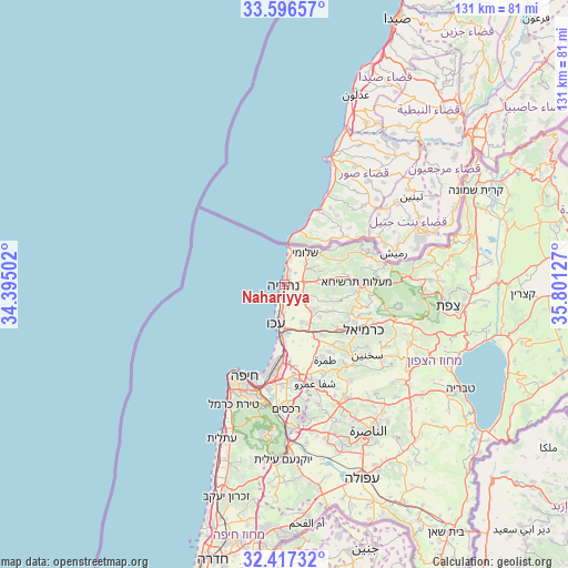
Nahariyya GPS coordinates[2]
33° 0' 32.112" North, 35° 5' 53.304" East
| Map corner | latitude | longitude |
|---|---|---|
| Upper-left | 33.59657°, | 34.39502° |
| Center: | 33.00892°, | 35.09814° |
| Lower-right: | 32.41732°, | 35.80127° |
| Map W x H: | 131.1×131.1 km | = 81.5×81.5mi |
| max Lat: | 33.27918° ⇑5.9% North |
| Nahariyya: | 33.00892° |
| min Lat: | ⇓94.1% South 29.55805° |
| min Long | Nahariyya | max Long |
| 34.57149° | 35.09814° | 35.81084° |
| W 52.7%⇐ | ⇒47.3% E |
Elevation
Elevation of Nahariyya is 15 m = 49 ft, and this is 208.4 m = 684 ft below average elevation for this country.
| Max E: |
988 m = 3241 ft | 93.5% |
| Avg. | 223.4 m = 733 ft | |
| Nahariyya | 15 m = 49 ft | |
Min E: |
-380 m = -1247 ft | 6.5% |
See also: Nahariyya elevation on elevation.city.
Geographical zone
Nahariyya is located in North temperate zone (between Tropic of Cancer and the Arctic Circle). Distance of this Northern Tropic circle is 1064.3 km =661.3 mi to South.| Distance of | km | miles | from Nahariyya |
|---|---|---|---|
| North Pole | 6336.8 | 3937.5 | to North |
| Arctic Circle | 3730.9 | 2318.3 | to North |
| Tropic Cancer | 1064.3 | 661.3 | to South |
| Equator | 3670.2 | 2280.6 | to South |


Nearby cities:
15 places around Nahariyya: (largest is in red/bold)
• Acre
9.2 km =5.7 mi,  192°
192°
• El Mazra‘a
2.8 km =1.7 mi,  179°
179°
• Esh Sheikh Dannūn
4.9 km =3 mi,  109°
109°
• Judeida Makr
10.5 km =6.5 mi,  148°
148°
• Kefar Rosh HaNiqra
8.7 km =5.4 mi,  9°
9°
• Kefar Weradim
16.8 km =10.4 mi,  95°
95°
• Kfar Yasif
8.5 km =5.3 mi,  135°
135°
• Kābūl
18.9 km =11.7 mi, 145°
• Mi‘ilyā
14.9 km =9.3 mi,  81°
81°
• Pasuta
20.1 km =12.5 mi, 77°
• Qiryat Moẕqin
19.2 km =11.9 mi, 185°
• Qiryat Yam
17.9 km =11.1 mi, 188°
• Shelomi
8.3 km =5.2 mi,  31°
31°
• Tamra
19.7 km =12.2 mi, 151°
• maalot Tarshīhā
15.7 km =9.8 mi,  86°
86°
Sources, notices
• [Note1] Compared only with cities in Israel existing in our database
• [Src1] Map data: © OpenStreetMap contributors (CC-BY-SA)
• [Src2] Other city data from geonames.org with taken over terms of usage.
• [Src3] Geographical zone / Annual Mean Temperature by Robert A. Rohde @ Wikipedia
