Vapi geodata
Vapi (Gujarat) is a populated place; located in India in Asia/Kolkata (GMT+5.5) time zone. With population of 71,395 people, there are 612 cities with bigger population in this country. Compared to other cities in India, 64% of cities are located further ↑North; 95.3% of cities are located further →East and 85.1% of cities have higher elevation than Vapi. Note1


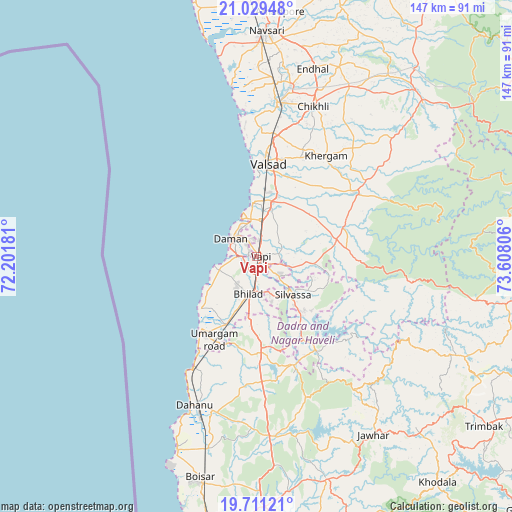
Vapi GPS coordinates[2]
20° 22' 18.3" North, 72° 54' 17.748" East
| Map corner | latitude | longitude |
|---|---|---|
| Upper-left | 21.02948°, | 72.20181° |
| Center: | 20.37175°, | 72.90493° |
| Lower-right: | 19.71121°, | 73.60806° |
| Map W x H: | 146.6×146.6 km | = 91.1×91.1mi |
| max Lat: | 34.9274° ⇑64% North |
| Vapi: | 20.37175° |
| min Lat: | ⇓36% South 8.09008° |
| min Long | Vapi | max Long |
| 68.82655° | 72.90493° | 96.81° |
| W 4.7%⇐ | ⇒95.3% E |
Elevation
Elevation of Vapi is 30 m = 98 ft, and this is 265.6 m = 871 ft below average elevation for this country.
| Max E: |
3681 m = 12077 ft | 85.1% |
| Avg. | 295.6 m = 970 ft | |
| Vapi | 30 m = 98 ft | |
Min E: |
1 m = 3 ft | 14.9% |
See also: Vapi elevation on elevation.city.
Geographical zone
Vapi is located in North Torrid zone (between Equator and Tropic of Cancer). Distance of this Northern Tropic circle is 340.8 km =211.8 mi to North.| Distance of | km | miles | from Vapi |
|---|---|---|---|
| North Pole | 7741.9 | 4810.6 | to North |
| Arctic Circle | 5136 | 3191.4 | to North |
| Tropic Cancer | 340.8 | 211.8 | to North |
| Equator | 2265.1 | 1407.5 | to South |


Nearby cities:
15 places around Vapi: (largest is in red/bold)
• Abrama
54.1 km =33.6 mi,  0°
0°
• Bilimora
44.6 km =27.7 mi,  7°
7°
• Chikhli
45.9 km =28.5 mi,  20°
20°
• Chinchani
59.9 km =37.2 mi,  202°
202°
• Dadra
8.2 km =5.1 mi,  129°
129°
• Daman
8.9 km =5.5 mi,  302°
302°
• Dharampur
33.5 km =20.8 mi,  56°
56°
• Dāhānu
49.2 km =30.6 mi, 204°
• Gandevi
49.9 km =31 mi, 11°
• Parnera
21.5 km =13.4 mi, 12°
• Pārdi
15.8 km =9.8 mi, 15°
• Silvassa
14.5 km =9 mi,  138°
138°
• Tārāpur
60.9 km =37.8 mi, 202°
• Valsād
26.7 km =16.6 mi, 6°
• Āmli
15.2 km =9.4 mi, 130°
Sources, notices
• [Note1] Compared only with cities in India existing in our database
• [Src1] Map data: © OpenStreetMap contributors (CC-BY-SA)
• [Src2] Other city data from geonames.org with taken over terms of usage.
• [Src3] Geographical zone / Annual Mean Temperature by Robert A. Rohde @ Wikipedia
