Dharampur geodata
Dharampur (Gujarat) is a populated place; located in India in Asia/Kolkata (GMT+5.5) time zone. With population of 21,207 people, there are 1956 cities with bigger population in this country. Compared to other cities in India, 63.6% of cities are located further ↑North; 93.8% of cities are located further →East and 73.6% of cities have higher elevation than Dharampur. Note1


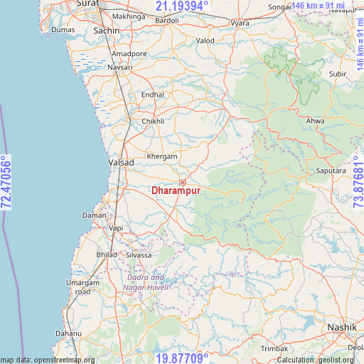
Dharampur GPS coordinates[2]
20° 32' 12.948" North, 73° 10' 25.248" East
| Map corner | latitude | longitude |
|---|---|---|
| Upper-left | 21.19394°, | 72.47056° |
| Center: | 20.53693°, | 73.17368° |
| Lower-right: | 19.87709°, | 73.87681° |
| Map W x H: | 146.4×146.4 km | = 91×91mi |
| max Lat: | 34.9274° ⇑63.6% North |
| Dharampur: | 20.53693° |
| min Lat: | ⇓36.4% South 8.09008° |
| min Long | Dharampur | max Long |
| 68.82655° | 73.17368° | 96.81° |
| W 6.2%⇐ | ⇒93.8% E |
Elevation
Elevation of Dharampur is 76 m = 249 ft, and this is 219.6 m = 720 ft below average elevation for this country.
| Max E: |
3681 m = 12077 ft | 73.6% |
| Avg. | 295.6 m = 970 ft | |
| Dharampur | 76 m = 249 ft | |
Min E: |
1 m = 3 ft | 26.4% |
See also: India elevation on elevation.city.
Geographical zone
Dharampur is located in North Torrid zone (between Equator and Tropic of Cancer). Distance of this Northern Tropic circle is 322.4 km =200.3 mi to North.| Distance of | km | miles | from Dharampur |
|---|---|---|---|
| North Pole | 7723.6 | 4799.2 | to North |
| Arctic Circle | 5117.7 | 3180 | to North |
| Tropic Cancer | 322.4 | 200.3 | to North |
| Equator | 2283.5 | 1418.9 | to South |


Nearby cities:
15 places around Dharampur: (largest is in red/bold)
• Abrama
45.3 km =28.1 mi,  322°
322°
• Bilimora
34 km =21.1 mi, 319°
• Chikhli
27.1 km =16.8 mi,  334°
334°
• Dadra
32 km =19.9 mi,  222°
222°
• Daman
38.1 km =23.7 mi,  249°
249°
• Gandevi
35.6 km =22.1 mi, 329°
• Parnera
23.6 km =14.7 mi,  276°
276°
• Pārdi
23.9 km =14.9 mi,  262°
262°
• Silvassa
34.6 km =21.5 mi,  212°
212°
• Surgāna
48.4 km =30.1 mi,  87°
87°
• Valsād
26.2 km =16.3 mi,  288°
288°
• Vapi
33.5 km =20.8 mi,  236°
236°
• Vānsada
31.6 km =19.6 mi,  38°
38°
• Waghāi
42.8 km =26.6 mi,  52°
52°
• Āmli
32.6 km =20.3 mi, 210°
Sources, notices
• [Note1] Compared only with cities in India existing in our database
• [Src1] Map data: © OpenStreetMap contributors (CC-BY-SA)
• [Src2] Other city data from geonames.org with taken over terms of usage.
• [Src3] Geographical zone / Annual Mean Temperature by Robert A. Rohde @ Wikipedia
