Dāhānu geodata
Dāhānu (Maharashtra) is a populated place; located in India in Asia/Kolkata (GMT+5.5) time zone. With population of 49,048 people, there are 901 cities with bigger population in this country. Compared to other cities in India, 65.3% of cities are located further ↑North; 96.3% of cities are located further →East and 98.3% of cities have higher elevation than Dāhānu. Note1


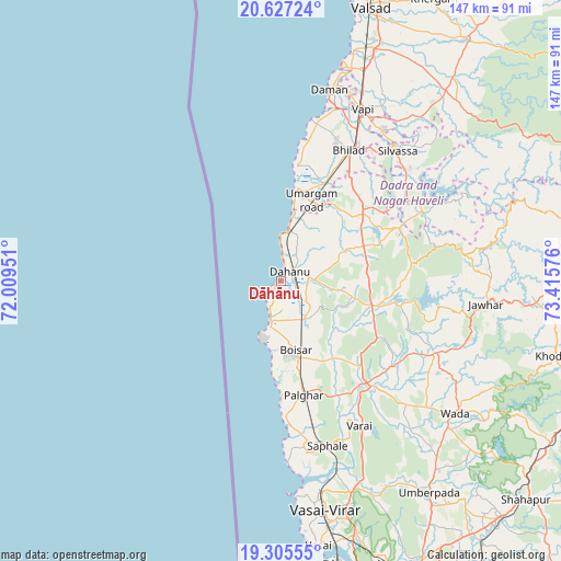
Dāhānu GPS coordinates[2]
19° 58' 4.008" North, 72° 42' 45.468" East
| Map corner | latitude | longitude |
|---|---|---|
| Upper-left | 20.62724°, | 72.00951° |
| Center: | 19.96778°, | 72.71263° |
| Lower-right: | 19.30555°, | 73.41576° |
| Map W x H: | 147×147 km | = 91.3×91.3mi |
| max Lat: | 34.9274° ⇑65.3% North |
| Dāhānu: | 19.96778° |
| min Lat: | ⇓34.7% South 8.09008° |
| min Long | Dāhānu | max Long |
| 68.82655° | 72.71263° | 96.81° |
| W 3.7%⇐ | ⇒96.3% E |
Elevation
Elevation of Dāhānu is 8 m = 26 ft, and this is 287.6 m = 944 ft below average elevation for this country.
| Max E: |
3681 m = 12077 ft | 98.3% |
| Avg. | 295.6 m = 970 ft | |
| Dāhānu | 8 m = 26 ft | |
Min E: |
1 m = 3 ft | 1.7% |
See also: Dāhānu elevation on elevation.city.
Geographical zone
Dāhānu is located in North Torrid zone (between Equator and Tropic of Cancer). Distance of this Northern Tropic circle is 385.7 km =239.7 mi to North.| Distance of | km | miles | from Dāhānu |
|---|---|---|---|
| North Pole | 7786.9 | 4838.6 | to North |
| Arctic Circle | 5181 | 3219.3 | to North |
| Tropic Cancer | 385.7 | 239.7 | to North |
| Equator | 2220.2 | 1379.6 | to South |


Nearby cities:
15 places around Dāhānu: (largest is in red/bold)
• Boisar
18.8 km =11.7 mi,  166°
166°
• Chinchani
10.8 km =6.7 mi,  195°
195°
• Dadra
47.7 km =29.6 mi,  33°
33°
• Daman
51.2 km =31.8 mi,  14°
14°
• Jawhār
54.1 km =33.6 mi,  96°
96°
• Manor
34 km =21.1 mi,  142°
142°
• Pālghar
30.6 km =19 mi, 169°
• Pārdi
64.9 km =40.3 mi,  22°
22°
• Shirgaon
30.2 km =18.8 mi,  179°
179°
• Silvassa
45.1 km =28 mi,  41°
41°
• Tārāpur
11.8 km =7.3 mi,  194°
194°
• Vapi
49.2 km =30.6 mi, 24°
• Virār
57.8 km =35.9 mi, 169°
• Vāda
57.4 km =35.7 mi,  127°
127°
• Āmli
47.3 km =29.4 mi, 42°
Sources, notices
• [Note1] Compared only with cities in India existing in our database
• [Src1] Map data: © OpenStreetMap contributors (CC-BY-SA)
• [Src2] Other city data from geonames.org with taken over terms of usage.
• [Src3] Geographical zone / Annual Mean Temperature by Robert A. Rohde @ Wikipedia
