Chinchani geodata
Chinchani (Maharashtra) is a populated place; located in India in Asia/Kolkata (GMT+5.5) time zone. With population of 14,357 people, there are 2527 cities with bigger population in this country. Compared to other cities in India, 65.7% of cities are located further ↑North; 96.4% of cities are located further →East and 93.5% of cities have higher elevation than Chinchani. Note1


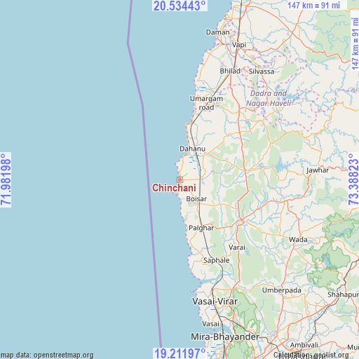
Chinchani GPS coordinates[2]
19° 52' 28.488" North, 72° 41' 6.36" East
| Map corner | latitude | longitude |
|---|---|---|
| Upper-left | 20.53443°, | 71.98198° |
| Center: | 19.87458°, | 72.6851° |
| Lower-right: | 19.21197°, | 73.38823° |
| Map W x H: | 147×147 km | = 91.3×91.3mi |
| max Lat: | 34.9274° ⇑65.7% North |
| Chinchani: | 19.87458° |
| min Lat: | ⇓34.3% South 8.09008° |
| min Long | Chinchani | max Long |
| 68.82655° | 72.6851° | 96.81° |
| W 3.6%⇐ | ⇒96.4% E |
Elevation
Elevation of Chinchani is 13 m = 43 ft, and this is 282.6 m = 927 ft below average elevation for this country.
| Max E: |
3681 m = 12077 ft | 93.5% |
| Avg. | 295.6 m = 970 ft | |
| Chinchani | 13 m = 43 ft | |
Min E: |
1 m = 3 ft | 6.5% |
See also: India elevation on elevation.city.
Geographical zone
Chinchani is located in North Torrid zone (between Equator and Tropic of Cancer). Distance of this Northern Tropic circle is 396.1 km =246.1 mi to North.| Distance of | km | miles | from Chinchani |
|---|---|---|---|
| North Pole | 7797.2 | 4845 | to North |
| Arctic Circle | 5191.3 | 3225.7 | to North |
| Tropic Cancer | 396.1 | 246.1 | to North |
| Equator | 2209.8 | 1373.1 | to South |


Nearby cities:
15 places around Chinchani: (largest is in red/bold)
• Bhayandar
66 km =41 mi,  164°
164°
• Boisar
10.8 km =6.7 mi,  136°
136°
• Dadra
58.1 km =36.1 mi,  30°
30°
• Daman
61.9 km =38.5 mi,  14°
14°
• Dāhānu
10.8 km =6.7 mi,  15°
15°
• Jawhār
56.8 km =35.3 mi,  85°
85°
• Manor
28.8 km =17.9 mi,  125°
125°
• Pālghar
21.5 km =13.4 mi, 156°
• Shirgaon
20.1 km =12.5 mi,  170°
170°
• Silvassa
55 km =34.2 mi,  36°
36°
• Tārāpur
1.1 km =0.7 mi,  184°
184°
• Vapi
59.9 km =37.2 mi, 22°
• Virār
48.4 km =30.1 mi, 164°
• Vāda
54.3 km =33.7 mi,  116°
116°
• Āmli
57.1 km =35.5 mi, 37°
Sources, notices
• [Note1] Compared only with cities in India existing in our database
• [Src1] Map data: © OpenStreetMap contributors (CC-BY-SA)
• [Src2] Other city data from geonames.org with taken over terms of usage.
• [Src3] Geographical zone / Annual Mean Temperature by Robert A. Rohde @ Wikipedia
