Ottappālam geodata
Ottappālam (Kerala) is a populated place; located in India in Asia/Kolkata (GMT+5.5) time zone. With population of 50,913 people, there are 875 cities with bigger population in this country. Compared to other cities in India, 94% of cities are located further ↑North; 69.6% of cities are located further →East and 81.1% of cities have higher elevation than Ottappālam. Note1


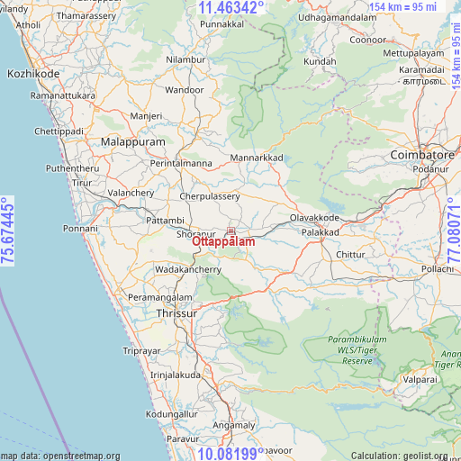
Ottappālam GPS coordinates[2]
10° 46' 24.6" North, 76° 22' 39.288" East
| Map corner | latitude | longitude |
|---|---|---|
| Upper-left | 11.46342°, | 75.67445° |
| Center: | 10.7735°, | 76.37758° |
| Lower-right: | 10.08199°, | 77.08071° |
| Map W x H: | 153.6×153.6 km | = 95.4×95.4mi |
| max Lat: | 34.9274° ⇑94% North |
| Ottappālam: | 10.7735° |
| min Lat: | ⇓6% South 8.09008° |
| min Long | Ottappālam | max Long |
| 68.82655° | 76.37758° | 96.81° |
| W 30.4%⇐ | ⇒69.6% E |
Elevation
Elevation of Ottappālam is 44 m = 144 ft, and this is 251.6 m = 825 ft below average elevation for this country.
| Max E: |
3681 m = 12077 ft | 81.1% |
| Avg. | 295.6 m = 970 ft | |
| Ottappālam | 44 m = 144 ft | |
Min E: |
1 m = 3 ft | 18.9% |
See also: Ottappālam elevation on elevation.city.
Geographical zone
Ottappālam is located in North Torrid zone (between Equator and Tropic of Cancer). Distance of Equator is 1197.9 km =744.3 mi to South.| Distance of | km | miles | from Ottappālam |
|---|---|---|---|
| North Pole | 8809.2 | 5473.8 | to North |
| Arctic Circle | 6203.3 | 3854.6 | to North |
| Tropic Cancer | 1408 | 874.9 | to North |
| Equator | 1197.9 | 744.3 | to South |


Nearby cities:
15 places around Ottappālam: (largest is in red/bold)
• Avanoor
28.7 km =17.8 mi,  230°
230°
• Cherpulassery
13.7 km =8.5 mi,  326°
326°
• Chetwayi
45.1 km =28 mi, 232°
• Chittūr
41.2 km =25.6 mi,  101°
101°
• Chēlakara
9.7 km =6 mi,  202°
202°
• Edakkulam
27.9 km =17.3 mi, 229°
• Guruvāyūr
41.8 km =26 mi,  241°
241°
• Kunnamkulam
36.8 km =22.9 mi,  247°
247°
• Malappuram
44 km =27.3 mi,  312°
312°
• Manjeri
47.7 km =29.6 mi,  323°
323°
• Mannārakkāt
26.1 km =16.2 mi,  21°
21°
• Pālghāt
30.2 km =18.8 mi,  90°
90°
• Shōranūr
11.7 km =7.3 mi,  263°
263°
• Thanniyam
47.8 km =29.7 mi,  213°
213°
• Thrissur
33.5 km =20.8 mi, 211°
Sources, notices
• [Note1] Compared only with cities in India existing in our database
• [Src1] Map data: © OpenStreetMap contributors (CC-BY-SA)
• [Src2] Other city data from geonames.org with taken over terms of usage.
• [Src3] Geographical zone / Annual Mean Temperature by Robert A. Rohde @ Wikipedia
