Chemmumiahpet geodata
Chemmumiahpet (Andhra Pradesh) is a populated place; located in India in Asia/Kolkata (GMT+5.5) time zone. With population of 31,416 people, there are 1379 cities with bigger population in this country. Compared to other cities in India, 78.2% of cities are located further ↑North; 62.1% of cities are located further ←West and 63.1% of cities have higher elevation than Chemmumiahpet. Note1


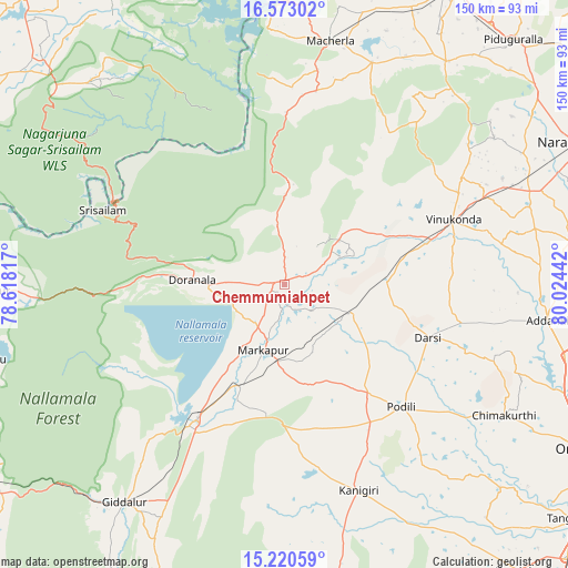
Chemmumiahpet GPS coordinates[2]
15° 53' 52.584" North, 79° 19' 16.644" East
| Map corner | latitude | longitude |
|---|---|---|
| Upper-left | 16.57302°, | 78.61817° |
| Center: | 15.89794°, | 79.32129° |
| Lower-right: | 15.22059°, | 80.02442° |
| Map W x H: | 150.4×150.4 km | = 93.5×93.5mi |
| max Lat: | 34.9274° ⇑78.2% North |
| Chemmumiahpet: | 15.89794° |
| min Lat: | ⇓21.8% South 8.09008° |
| min Long | Chemmumiahpet | max Long |
| 68.82655° | 79.32129° | 96.81° |
| W 62.1%⇐ | ⇒37.9% E |
Elevation
Elevation of Chemmumiahpet is 132 m = 433 ft, and this is 163.6 m = 537 ft below average elevation for this country.
| Max E: |
3681 m = 12077 ft | 63.1% |
| Avg. | 295.6 m = 970 ft | |
| Chemmumiahpet | 132 m = 433 ft | |
Min E: |
1 m = 3 ft | 36.9% |
See also: India elevation on elevation.city.
Geographical zone
Chemmumiahpet is located in North Torrid zone (between Equator and Tropic of Cancer). Distance of this Northern Tropic circle is 838.2 km =520.8 mi to North.| Distance of | km | miles | from Chemmumiahpet |
|---|---|---|---|
| North Pole | 8239.4 | 5119.7 | to North |
| Arctic Circle | 5633.5 | 3500.5 | to North |
| Tropic Cancer | 838.2 | 520.8 | to North |
| Equator | 1767.7 | 1098.4 | to South |


Nearby cities:
15 places around Chemmumiahpet: (largest is in red/bold)
• Addanki
70.4 km =43.7 mi,  97°
97°
• Atmakūr
78.5 km =48.8 mi,  268°
268°
• Cumbum
41.8 km =26 mi,  212°
212°
• Darsi
40.9 km =25.4 mi,  110°
110°
• Diguvametta
76.8 km =47.7 mi,  223°
223°
• Giddalūr
72 km =44.7 mi, 216°
• Govindapuram,Chilakaluripet,Guntur
88.3 km =54.9 mi,  71°
71°
• Kanigiri
58.2 km =36.2 mi,  160°
160°
• Mācherla
65.5 km =40.7 mi,  10°
10°
• Mārkāpur
18.9 km =11.7 mi,  197°
197°
• Narasaraopet
86.3 km =53.6 mi,  64°
64°
• Ongole
89 km =55.3 mi,  119°
119°
• Srīsailain
52.2 km =32.4 mi,  291°
291°
• Vinukonda
47.9 km =29.8 mi, 68°
• pedda nakkalapalem
90 km =55.9 mi,  92°
92°
Sources, notices
• [Note1] Compared only with cities in India existing in our database
• [Src1] Map data: © OpenStreetMap contributors (CC-BY-SA)
• [Src2] Other city data from geonames.org with taken over terms of usage.
• [Src3] Geographical zone / Annual Mean Temperature by Robert A. Rohde @ Wikipedia
