Ongole geodata
Ongole (Andhra Pradesh) is a populated place; located in India in Asia/Kolkata (GMT+5.5) time zone. With population of 172,872 people, there are 248 cities with bigger population in this country. Compared to other cities in India, 79.7% of cities are located further ↑North; 68.1% of cities are located further ←West and 85.8% of cities have higher elevation than Ongole. Note1


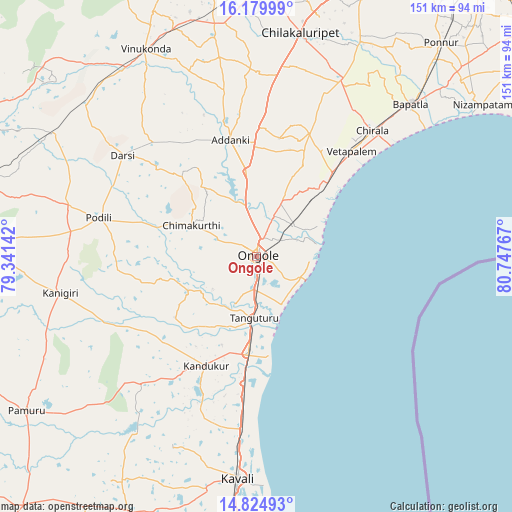
Ongole GPS coordinates[2]
15° 30' 12.852" North, 80° 2' 40.344" East
| Map corner | latitude | longitude |
|---|---|---|
| Upper-left | 16.17999°, | 79.34142° |
| Center: | 15.50357°, | 80.04454° |
| Lower-right: | 14.82493°, | 80.74767° |
| Map W x H: | 150.7×150.7 km | = 93.6×93.6mi |
| max Lat: | 34.9274° ⇑79.7% North |
| Ongole: | 15.50357° |
| min Lat: | ⇓20.3% South 8.09008° |
| min Long | Ongole | max Long |
| 68.82655° | 80.04454° | 96.81° |
| W 68.1%⇐ | ⇒31.9% E |
Elevation
Elevation of Ongole is 28 m = 92 ft, and this is 267.6 m = 878 ft below average elevation for this country.
| Max E: |
3681 m = 12077 ft | 85.8% |
| Avg. | 295.6 m = 970 ft | |
| Ongole | 28 m = 92 ft | |
Min E: |
1 m = 3 ft | 14.2% |
See also: Ongole elevation on elevation.city.
Geographical zone
Ongole is located in North Torrid zone (between Equator and Tropic of Cancer). Distance of this Northern Tropic circle is 882.1 km =548.1 mi to North.| Distance of | km | miles | from Ongole |
|---|---|---|---|
| North Pole | 8283.2 | 5146.9 | to North |
| Arctic Circle | 5677.3 | 3527.7 | to North |
| Tropic Cancer | 882.1 | 548.1 | to North |
| Equator | 1723.8 | 1071.1 | to South |


Nearby cities:
15 places around Ongole: (largest is in red/bold)
• Addanki
35 km =21.7 mi,  347°
347°
• Bāpatla
63.5 km =39.5 mi,  45°
45°
• Chilakalūrupet
66.5 km =41.3 mi,  11°
11°
• Chīrāla
48.5 km =30.1 mi,  42°
42°
• Darsi
49 km =30.4 mi,  307°
307°
• Govindapuram,Chilakaluripet,Guntur
72.7 km =45.2 mi,  4°
4°
• Kandukūr
35.4 km =22 mi,  205°
205°
• Kanigiri
58.6 km =36.4 mi,  259°
259°
• Kāvali
65.5 km =40.7 mi,  184°
184°
• Narasaraopet
81.3 km =50.5 mi, 0°
• Pavuluru
40.9 km =25.4 mi,  18°
18°
• Singarāyakonda
30.4 km =18.9 mi, 183°
• Vetapālem
42 km =26.1 mi, 41°
• Vinukonda
69.3 km =43.1 mi,  331°
331°
• pedda nakkalapalem
42.3 km =26.3 mi, 17°
Sources, notices
• [Note1] Compared only with cities in India existing in our database
• [Src1] Map data: © OpenStreetMap contributors (CC-BY-SA)
• [Src2] Other city data from geonames.org with taken over terms of usage.
• [Src3] Geographical zone / Annual Mean Temperature by Robert A. Rohde @ Wikipedia
