Mācherla geodata
Mācherla (Andhra Pradesh) is a populated place; located in India in Asia/Kolkata (GMT+5.5) time zone. With population of 51,039 people, there are 872 cities with bigger population in this country. Compared to other cities in India, 76.6% of cities are located further ↑North; 63.1% of cities are located further ←West and 61.1% of cities have higher elevation than Mācherla. Note1


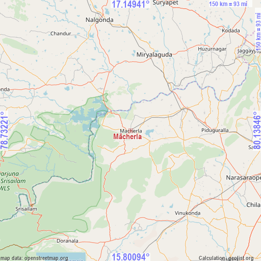
Mācherla GPS coordinates[2]
16° 28' 34.86" North, 79° 26' 7.188" East
| Map corner | latitude | longitude |
|---|---|---|
| Upper-left | 17.14941°, | 78.73221° |
| Center: | 16.47635°, | 79.43533° |
| Lower-right: | 15.80094°, | 80.13846° |
| Map W x H: | 149.9×149.9 km | = 93.1×93.1mi |
| max Lat: | 34.9274° ⇑76.6% North |
| Mācherla: | 16.47635° |
| min Lat: | ⇓23.4% South 8.09008° |
| min Long | Mācherla | max Long |
| 68.82655° | 79.43533° | 96.81° |
| W 63.1%⇐ | ⇒36.9% E |
Elevation
Elevation of Mācherla is 142 m = 466 ft, and this is 153.6 m = 504 ft below average elevation for this country.
| Max E: |
3681 m = 12077 ft | 61.1% |
| Avg. | 295.6 m = 970 ft | |
| Mācherla | 142 m = 466 ft | |
Min E: |
1 m = 3 ft | 38.9% |
See also: Mācherla elevation on elevation.city.
Geographical zone
Mācherla is located in North Torrid zone (between Equator and Tropic of Cancer). Distance of this Northern Tropic circle is 773.9 km =480.9 mi to North.| Distance of | km | miles | from Mācherla |
|---|---|---|---|
| North Pole | 8175.1 | 5079.8 | to North |
| Arctic Circle | 5569.2 | 3460.5 | to North |
| Tropic Cancer | 773.9 | 480.9 | to North |
| Equator | 1832 | 1138.4 | to South |


Nearby cities:
15 places around Mācherla: (largest is in red/bold)
• Chemmumiahpet
65.5 km =40.7 mi,  190°
190°
• Chilakalūrupet
89.1 km =55.4 mi,  118°
118°
• Darsi
82.8 km =51.4 mi,  161°
161°
• Devarkonda
59.8 km =37.2 mi,  293°
293°
• Govindapuram,Chilakaluripet,Guntur
79.7 km =49.5 mi, 116°
• Jaggayyapeta
84.5 km =52.5 mi,  56°
56°
• Kodār
81 km =50.3 mi,  44°
44°
• Miriālgūda
46.1 km =28.6 mi,  17°
17°
• Mārkāpur
84.3 km =52.4 mi, 192°
• Nalgonda
66.7 km =41.4 mi,  344°
344°
• Narasaraopet
70.8 km =44 mi,  112°
112°
• Sattenapalle
77 km =47.8 mi,  96°
96°
• Srīsailain
75.4 km =46.9 mi,  233°
233°
• Suriāpet
76.4 km =47.5 mi,  14°
14°
• Vinukonda
57.2 km =35.5 mi,  145°
145°
Sources, notices
• [Note1] Compared only with cities in India existing in our database
• [Src1] Map data: © OpenStreetMap contributors (CC-BY-SA)
• [Src2] Other city data from geonames.org with taken over terms of usage.
• [Src3] Geographical zone / Annual Mean Temperature by Robert A. Rohde @ Wikipedia
