Narasaraopet geodata
Narasaraopet (Andhra Pradesh) is a populated place; located in India in Asia/Kolkata (GMT+5.5) time zone. With population of 97,194 people, there are 457 cities with bigger population in this country. Compared to other cities in India, 77.4% of cities are located further ↑North; 68.1% of cities are located further ←West and 73.6% of cities have higher elevation than Narasaraopet. Note1


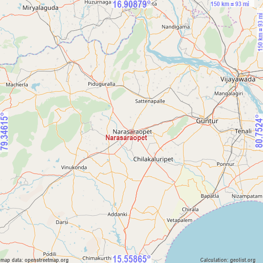
Narasaraopet GPS coordinates[2]
16° 14' 5.568" North, 80° 2' 57.372" East
| Map corner | latitude | longitude |
|---|---|---|
| Upper-left | 16.90879°, | 79.34615° |
| Center: | 16.23488°, | 80.04927° |
| Lower-right: | 15.55865°, | 80.7524° |
| Map W x H: | 150.1×150.1 km | = 93.3×93.3mi |
| max Lat: | 34.9274° ⇑77.4% North |
| Narasaraopet: | 16.23488° |
| min Lat: | ⇓22.6% South 8.09008° |
| min Long | Narasaraopet | max Long |
| 68.82655° | 80.04927° | 96.81° |
| W 68.1%⇐ | ⇒31.9% E |
Elevation
Elevation of Narasaraopet is 76 m = 249 ft, and this is 219.6 m = 720 ft below average elevation for this country.
| Max E: |
3681 m = 12077 ft | 73.6% |
| Avg. | 295.6 m = 970 ft | |
| Narasaraopet | 76 m = 249 ft | |
Min E: |
1 m = 3 ft | 26.4% |
See also: Narasaraopet elevation on elevation.city.
Geographical zone
Narasaraopet is located in North Torrid zone (between Equator and Tropic of Cancer). Distance of this Northern Tropic circle is 800.8 km =497.6 mi to North.| Distance of | km | miles | from Narasaraopet |
|---|---|---|---|
| North Pole | 8201.9 | 5096.4 | to North |
| Arctic Circle | 5596 | 3477.2 | to North |
| Tropic Cancer | 800.8 | 497.6 | to North |
| Equator | 1805.1 | 1121.6 | to South |


Nearby cities:
15 places around Narasaraopet: (largest is in red/bold)
• Addanki
47.9 km =29.8 mi,  189°
189°
• Bāpatla
57.9 km =36 mi,  129°
129°
• Chilakalūrupet
20.4 km =12.7 mi,  142°
142°
• Chīrāla
56 km =34.8 mi, 144°
• Govindapuram,Chilakaluripet,Guntur
10.6 km =6.6 mi,  147°
147°
• Guntur
44.1 km =27.4 mi,  80°
80°
• Mangalagiri
59.5 km =37 mi,  68°
68°
• Pavuluru
44.2 km =27.5 mi,  163°
163°
• Phirangipuram
23.6 km =14.7 mi, 74°
• Ponnur
56.4 km =35 mi,  108°
108°
• Ponnūru
56.9 km =35.4 mi, 109°
• Sattenapalle
20.8 km =12.9 mi,  31°
31°
• Vetapālem
57.1 km =35.5 mi, 151°
• Vinukonda
38.8 km =24.1 mi,  238°
238°
• pedda nakkalapalem
42.7 km =26.5 mi, 163°
Sources, notices
• [Note1] Compared only with cities in India existing in our database
• [Src1] Map data: © OpenStreetMap contributors (CC-BY-SA)
• [Src2] Other city data from geonames.org with taken over terms of usage.
• [Src3] Geographical zone / Annual Mean Temperature by Robert A. Rohde @ Wikipedia
