Addanki geodata
Addanki (Andhra Pradesh) is a populated place; located in India in Asia/Kolkata (GMT+5.5) time zone. With population of 28,547 people, there are 1511 cities with bigger population in this country. Compared to other cities in India, 78.6% of cities are located further ↑North; 67.6% of cities are located further ←West and 81.9% of cities have higher elevation than Addanki. Note1


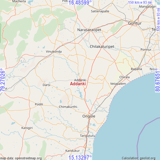
Addanki GPS coordinates[2]
15° 48' 38.196" North, 79° 58' 24.168" East
| Map corner | latitude | longitude |
|---|---|---|
| Upper-left | 16.48599°, | 79.27026° |
| Center: | 15.81061°, | 79.97338° |
| Lower-right: | 15.13297°, | 80.67651° |
| Map W x H: | 150.4×150.4 km | = 93.5×93.5mi |
| max Lat: | 34.9274° ⇑78.6% North |
| Addanki: | 15.81061° |
| min Lat: | ⇓21.4% South 8.09008° |
| min Long | Addanki | max Long |
| 68.82655° | 79.97338° | 96.81° |
| W 67.6%⇐ | ⇒32.4% E |
Elevation
Elevation of Addanki is 41 m = 135 ft, and this is 254.6 m = 835 ft below average elevation for this country.
| Max E: |
3681 m = 12077 ft | 81.9% |
| Avg. | 295.6 m = 970 ft | |
| Addanki | 41 m = 135 ft | |
Min E: |
1 m = 3 ft | 18.1% |
See also: India elevation on elevation.city.
Geographical zone
Addanki is located in North Torrid zone (between Equator and Tropic of Cancer). Distance of this Northern Tropic circle is 847.9 km =526.9 mi to North.| Distance of | km | miles | from Addanki |
|---|---|---|---|
| North Pole | 8249.1 | 5125.8 | to North |
| Arctic Circle | 5643.2 | 3506.5 | to North |
| Tropic Cancer | 847.9 | 526.9 | to North |
| Equator | 1758 | 1092.4 | to South |


Nearby cities:
15 places around Addanki: (largest is in red/bold)
• Bāpatla
53.9 km =33.5 mi,  78°
78°
• Chilakalūrupet
37.3 km =23.2 mi,  33°
33°
• Chīrāla
40.6 km =25.2 mi,  87°
87°
• Darsi
31.8 km =19.8 mi,  261°
261°
• Govindapuram,Chilakaluripet,Guntur
40.7 km =25.3 mi,  19°
19°
• Kandukūr
66.6 km =41.4 mi,  186°
186°
• Kanigiri
67.3 km =41.8 mi,  227°
227°
• Narasaraopet
47.9 km =29.8 mi,  9°
9°
• Ongole
35 km =21.7 mi,  167°
167°
• Pavuluru
21 km =13 mi, 77°
• Phirangipuram
61.7 km =38.3 mi, 30°
• Singarāyakonda
64.8 km =40.3 mi, 174°
• Vetapālem
35.8 km =22.2 mi, 94°
• Vinukonda
36.8 km =22.9 mi,  317°
317°
• pedda nakkalapalem
21.1 km =13.1 mi,  72°
72°
Sources, notices
• [Note1] Compared only with cities in India existing in our database
• [Src1] Map data: © OpenStreetMap contributors (CC-BY-SA)
• [Src2] Other city data from geonames.org with taken over terms of usage.
• [Src3] Geographical zone / Annual Mean Temperature by Robert A. Rohde @ Wikipedia
