Atmakūr geodata
Atmakūr (Andhra Pradesh) is a populated place; located in India in Asia/Kolkata (GMT+5.5) time zone. With population of 35,137 people, there are 1237 cities with bigger population in this country. Compared to other cities in India, 78.3% of cities are located further ↑North; 55% of cities are located further ←West and 66.2% of cities have lower elevation than Atmakūr. Note1


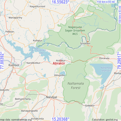
Atmakūr GPS coordinates[2]
15° 52' 51.924" North, 78° 35' 13.344" East
| Map corner | latitude | longitude |
|---|---|---|
| Upper-left | 16.55623°, | 77.88392° |
| Center: | 15.88109°, | 78.58704° |
| Lower-right: | 15.20368°, | 79.29017° |
| Map W x H: | 150.4×150.4 km | = 93.5×93.5mi |
| max Lat: | 34.9274° ⇑78.3% North |
| Atmakūr: | 15.88109° |
| min Lat: | ⇓21.7% South 8.09008° |
| min Long | Atmakūr | max Long |
| 68.82655° | 78.58704° | 96.81° |
| W 55%⇐ | ⇒45% E |
Elevation
Elevation of Atmakūr is 295 m = 968 ft, and this is 0.60000000000002 m = 2 ft below average elevation for this country.
| Max E: |
3681 m = 12077 ft | 33.8% |
| Avg. | 295.6 m = 970 ft | |
| Atmakūr | 295 m = 968 ft | |
Min E: |
1 m = 3 ft | 66.2% |
See also: India elevation on elevation.city.
Geographical zone
Atmakūr is located in North Torrid zone (between Equator and Tropic of Cancer). Distance of this Northern Tropic circle is 840.1 km =522 mi to North.| Distance of | km | miles | from Atmakūr |
|---|---|---|---|
| North Pole | 8241.3 | 5120.9 | to North |
| Arctic Circle | 5635.4 | 3501.7 | to North |
| Tropic Cancer | 840.1 | 522 | to North |
| Equator | 1765.8 | 1097.2 | to South |


Nearby cities:
15 places around Atmakūr: (largest is in red/bold)
• Banganapalle
73.6 km =45.7 mi,  211°
211°
• Betamcherla
67 km =41.6 mi,  224°
224°
• Chemmumiahpet
78.5 km =48.8 mi,  88°
88°
• Cumbum
65.2 km =40.5 mi,  120°
120°
• Diguvametta
59.9 km =37.2 mi,  154°
154°
• Gadwāl
93.3 km =58 mi,  294°
294°
• Giddalūr
67 km =41.6 mi, 147°
• Kurnool
59.2 km =36.8 mi,  264°
264°
• Mārkāpur
74.7 km =46.4 mi,  102°
102°
• Nandikotkūr
34.5 km =21.4 mi,  265°
265°
• Nandyāl
46.2 km =28.7 mi,  193°
193°
• Nāgar Karnūl
72.5 km =45 mi,  337°
337°
• Srīsailain
36.8 km =22.9 mi,  54°
54°
• Wanparti
77.4 km =48.1 mi,  314°
314°
• Ālampur
48.5 km =30.1 mi, 269°
Sources, notices
• [Note1] Compared only with cities in India existing in our database
• [Src1] Map data: © OpenStreetMap contributors (CC-BY-SA)
• [Src2] Other city data from geonames.org with taken over terms of usage.
• [Src3] Geographical zone / Annual Mean Temperature by Robert A. Rohde @ Wikipedia
