Mannārakkāt geodata
Mannārakkāt (Kerala) is a populated place; located in India in Asia/Kolkata (GMT+5.5) time zone. With population of 50,921 people, there are 874 cities with bigger population in this country. Compared to other cities in India, 93.2% of cities are located further ↑North; 68.8% of cities are located further →East and 71.8% of cities have higher elevation than Mannārakkāt. Note1


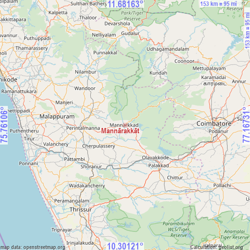
Mannārakkāt GPS coordinates[2]
10° 59' 32.028" North, 76° 27' 51.048" East
| Map corner | latitude | longitude |
|---|---|---|
| Upper-left | 11.68163°, | 75.76106° |
| Center: | 10.99223°, | 76.46418° |
| Lower-right: | 10.30121°, | 77.16731° |
| Map W x H: | 153.5×153.5 km | = 95.4×95.4mi |
| max Lat: | 34.9274° ⇑93.2% North |
| Mannārakkāt: | 10.99223° |
| min Lat: | ⇓6.8% South 8.09008° |
| min Long | Mannārakkāt | max Long |
| 68.82655° | 76.46418° | 96.81° |
| W 31.2%⇐ | ⇒68.8% E |
Elevation
Elevation of Mannārakkāt is 85 m = 279 ft, and this is 210.6 m = 691 ft below average elevation for this country.
| Max E: |
3681 m = 12077 ft | 71.8% |
| Avg. | 295.6 m = 970 ft | |
| Mannārakkāt | 85 m = 279 ft | |
Min E: |
1 m = 3 ft | 28.2% |
See also: Mannārakkāt elevation on elevation.city.
Geographical zone
Mannārakkāt is located in North Torrid zone (between Equator and Tropic of Cancer). Distance of Equator is 1222.2 km =759.4 mi to South.| Distance of | km | miles | from Mannārakkāt |
|---|---|---|---|
| North Pole | 8784.8 | 5458.6 | to North |
| Arctic Circle | 6179 | 3839.5 | to North |
| Tropic Cancer | 1383.7 | 859.8 | to North |
| Equator | 1222.2 | 759.4 | to South |


Nearby cities:
15 places around Mannārakkāt: (largest is in red/bold)
• Aruvankad
52.2 km =32.4 mi,  37°
37°
• Avanoor
53 km =32.9 mi,  216°
216°
• Cherpulassery
21.2 km =13.2 mi,  232°
232°
• Chittūr
44.9 km =27.9 mi,  136°
136°
• Chēlakara
35.8 km =22.2 mi,  201°
201°
• Coimbatore
54.8 km =34.1 mi,  88°
88°
• Edakkulam
52.4 km =32.6 mi, 215°
• Malappuram
42.1 km =26.2 mi,  277°
277°
• Manjeri
40.2 km =25 mi,  290°
290°
• Ooty
53.2 km =33.1 mi,  28°
28°
• Ottappālam
26.1 km =16.2 mi, 201°
• Perūr
49 km =30.4 mi, 92°
• Pālghāt
32 km =19.9 mi, 139°
• Shōranūr
33.2 km =20.6 mi, 219°
• Wellington
54.2 km =33.7 mi, 40°
Sources, notices
• [Note1] Compared only with cities in India existing in our database
• [Src1] Map data: © OpenStreetMap contributors (CC-BY-SA)
• [Src2] Other city data from geonames.org with taken over terms of usage.
• [Src3] Geographical zone / Annual Mean Temperature by Robert A. Rohde @ Wikipedia
