Akasahebpet geodata
Akasahebpet (Andhra Pradesh) is a populated place; located in India in Asia/Kolkata (GMT+5.5) time zone. With population of 1,500 people, there are 3448 cities with bigger population in this country. Compared to other cities in India, 73.2% of cities are located further ↑North; 78.1% of cities are located further ←West and 74.4% of cities have higher elevation than Akasahebpet. Note1


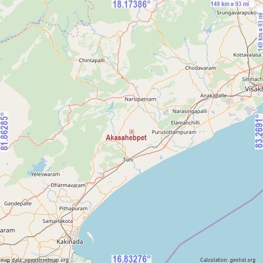
Akasahebpet GPS coordinates[2]
17° 30' 16.38" North, 82° 33' 57.492" East
| Map corner | latitude | longitude |
|---|---|---|
| Upper-left | 18.17386°, | 81.86285° |
| Center: | 17.50455°, | 82.56597° |
| Lower-right: | 16.83276°, | 83.2691° |
| Map W x H: | 149.1×149.1 km | = 92.6×92.6mi |
| max Lat: | 34.9274° ⇑73.2% North |
| Akasahebpet: | 17.50455° |
| min Lat: | ⇓26.8% South 8.09008° |
| min Long | Akasahebpet | max Long |
| 68.82655° | 82.56597° | 96.81° |
| W 78.1%⇐ | ⇒21.9% E |
Elevation
Elevation of Akasahebpet is 71 m = 233 ft, and this is 224.6 m = 737 ft below average elevation for this country.
| Max E: |
3681 m = 12077 ft | 74.4% |
| Avg. | 295.6 m = 970 ft | |
| Akasahebpet | 71 m = 233 ft | |
Min E: |
1 m = 3 ft | 25.6% |
See also: India elevation on elevation.city.
Geographical zone
Akasahebpet is located in North Torrid zone (between Equator and Tropic of Cancer). Distance of this Northern Tropic circle is 659.6 km =409.9 mi to North.| Distance of | km | miles | from Akasahebpet |
|---|---|---|---|
| North Pole | 8060.7 | 5008.7 | to North |
| Arctic Circle | 5454.9 | 3389.5 | to North |
| Tropic Cancer | 659.6 | 409.9 | to North |
| Equator | 1946.3 | 1209.4 | to South |


Nearby cities:
15 places around Akasahebpet: (largest is in red/bold)
• Anakāpalle
50.9 km =31.6 mi,  65°
65°
• Chodavaram
53.2 km =33.1 mi,  47°
47°
• Elamanchili
31.3 km =19.4 mi,  80°
80°
• Etikoppāka
17.8 km =11.1 mi,  91°
91°
• Gajuwaka
72.3 km =44.9 mi, 72°
• Kākināda
69.8 km =43.4 mi,  209°
209°
• Mādugula
52.8 km =32.8 mi,  30°
30°
• Narsīpatnam
18.7 km =11.6 mi,  15°
15°
• Peddāpuram
65.7 km =40.8 mi,  223°
223°
• Pithāpuram
54.4 km =33.8 mi, 217°
• Ramanayyapeta
71.3 km =44.3 mi, 209°
• Sāmalkot
64.7 km =40.2 mi, 219°
• Tuni
16.3 km =10.1 mi,  187°
187°
• Visakhapatnam
70.1 km =43.6 mi, 73°
• vadlamuru
62.3 km =38.7 mi, 223°
Sources, notices
• [Note1] Compared only with cities in India existing in our database
• [Src1] Map data: © OpenStreetMap contributors (CC-BY-SA)
• [Src2] Other city data from geonames.org with taken over terms of usage.
• [Src3] Geographical zone / Annual Mean Temperature by Robert A. Rohde @ Wikipedia
