Visakhapatnam geodata
Visakhapatnam (Andhra Pradesh) is a seat of a second-order administrative division; located in India in Asia/Kolkata (GMT+5.5) time zone. With population of 1,063,178 people, there are 36 cities with bigger population in this country. Compared to other cities in India, 72.5% of cities are located further ↑North; 79.9% of cities are located further ←West and 87.2% of cities have higher elevation than Visakhapatnam. Note1


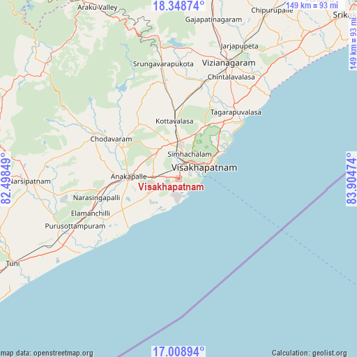
Visakhapatnam GPS coordinates[2]
17° 40' 48.324" North, 83° 12' 5.796" East
| Map corner | latitude | longitude |
|---|---|---|
| Upper-left | 18.34874°, | 82.49849° |
| Center: | 17.68009°, | 83.20161° |
| Lower-right: | 17.00894°, | 83.90474° |
| Map W x H: | 149×149 km | = 92.6×92.6mi |
| max Lat: | 34.9274° ⇑72.5% North |
| Visakhapatnam: | 17.68009° |
| min Lat: | ⇓27.5% South 8.09008° |
| min Long | Visakhapatnam | max Long |
| 68.82655° | 83.20161° | 96.81° |
| W 79.9%⇐ | ⇒20.1% E |
Elevation
Elevation of Visakhapatnam is 24 m = 79 ft, and this is 271.6 m = 891 ft below average elevation for this country.
| Max E: |
3681 m = 12077 ft | 87.2% |
| Avg. | 295.6 m = 970 ft | |
| Visakhapatnam | 24 m = 79 ft | |
Min E: |
1 m = 3 ft | 12.8% |
See also: Visakhapatnam elevation on elevation.city.
Geographical zone
Visakhapatnam is located in North Torrid zone (between Equator and Tropic of Cancer). Distance of this Northern Tropic circle is 640.1 km =397.7 mi to North.| Distance of | km | miles | from Visakhapatnam |
|---|---|---|---|
| North Pole | 8041.2 | 4996.6 | to North |
| Arctic Circle | 5435.3 | 3377.3 | to North |
| Tropic Cancer | 640.1 | 397.7 | to North |
| Equator | 1965.8 | 1221.5 | to South |


Nearby cities:
15 places around Visakhapatnam: (largest is in red/bold)
• Akasahebpet
70.1 km =43.6 mi,  253°
253°
• Anakāpalle
21 km =13 mi,  273°
273°
• Bhīmunipatnam
35.3 km =21.9 mi,  48°
48°
• Chodavaram
32.7 km =20.3 mi,  300°
300°
• Chīpurupalle
80.2 km =49.8 mi,  28°
28°
• Elamanchili
39.3 km =24.4 mi, 248°
• Etikoppāka
53.5 km =33.2 mi, 248°
• Gajuwaka
2.7 km =1.7 mi,  35°
35°
• Mādugula
48.5 km =30.1 mi, 302°
• Narsīpatnam
62.4 km =38.8 mi, 268°
• Sālūr
93.1 km =57.8 mi,  0°
0°
• Tuni
78.1 km =48.5 mi,  242°
242°
• Vepagunta
11 km =6.8 mi,  7°
7°
• Vizianagaram
53.4 km =33.2 mi,  24°
24°
• Yārāda
8 km =5 mi,  107°
107°
Sources, notices
• [Note1] Compared only with cities in India existing in our database
• [Src1] Map data: © OpenStreetMap contributors (CC-BY-SA)
• [Src2] Other city data from geonames.org with taken over terms of usage.
• [Src3] Geographical zone / Annual Mean Temperature by Robert A. Rohde @ Wikipedia
