Chodavaram geodata
Chodavaram (Andhra Pradesh) is a populated place; located in India in Asia/Kolkata (GMT+5.5) time zone. With population of 29,000 people, there are 1495 cities with bigger population in this country. Compared to other cities in India, 72.1% of cities are located further ↑North; 79.1% of cities are located further ←West and 79.9% of cities have higher elevation than Chodavaram. Note1


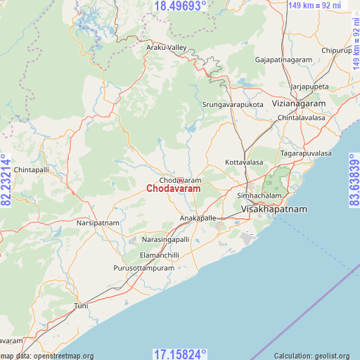
Chodavaram GPS coordinates[2]
17° 49' 43.824" North, 82° 56' 6.936" East
| Map corner | latitude | longitude |
|---|---|---|
| Upper-left | 18.49693°, | 82.23214° |
| Center: | 17.82884°, | 82.93526° |
| Lower-right: | 17.15824°, | 83.63839° |
| Map W x H: | 148.8×148.9 km | = 92.5×92.5mi |
| max Lat: | 34.9274° ⇑72.1% North |
| Chodavaram: | 17.82884° |
| min Lat: | ⇓27.9% South 8.09008° |
| min Long | Chodavaram | max Long |
| 68.82655° | 82.93526° | 96.81° |
| W 79.1%⇐ | ⇒20.9% E |
Elevation
Elevation of Chodavaram is 48 m = 157 ft, and this is 247.6 m = 812 ft below average elevation for this country.
| Max E: |
3681 m = 12077 ft | 79.9% |
| Avg. | 295.6 m = 970 ft | |
| Chodavaram | 48 m = 157 ft | |
Min E: |
1 m = 3 ft | 20.1% |
See also: India elevation on elevation.city.
Geographical zone
Chodavaram is located in North Torrid zone (between Equator and Tropic of Cancer). Distance of this Northern Tropic circle is 623.5 km =387.4 mi to North.| Distance of | km | miles | from Chodavaram |
|---|---|---|---|
| North Pole | 8024.7 | 4986.3 | to North |
| Arctic Circle | 5418.8 | 3367.1 | to North |
| Tropic Cancer | 623.5 | 387.4 | to North |
| Equator | 1982.4 | 1231.8 | to South |


Nearby cities:
15 places around Chodavaram: (largest is in red/bold)
• Akasahebpet
53.2 km =33.1 mi,  227°
227°
• Anakāpalle
16.9 km =10.5 mi,  154°
154°
• Bhīmunipatnam
55.1 km =34.2 mi,  82°
82°
• Chīpurupalle
85.8 km =53.3 mi,  51°
51°
• Elamanchili
32.2 km =20 mi,  194°
194°
• Etikoppāka
42.4 km =26.3 mi,  210°
210°
• Gajuwaka
33.1 km =20.6 mi,  115°
115°
• Mādugula
15.9 km =9.9 mi,  307°
307°
• Narsīpatnam
38.6 km =24 mi,  242°
242°
• Sālūr
81.7 km =50.8 mi,  20°
20°
• Tuni
66.6 km =41.4 mi,  218°
218°
• Vepagunta
30.2 km =18.8 mi,  100°
100°
• Visakhapatnam
32.7 km =20.3 mi, 120°
• Vizianagaram
59.7 km =37.1 mi,  57°
57°
• Yārāda
40.6 km =25.2 mi, 117°
Sources, notices
• [Note1] Compared only with cities in India existing in our database
• [Src1] Map data: © OpenStreetMap contributors (CC-BY-SA)
• [Src2] Other city data from geonames.org with taken over terms of usage.
• [Src3] Geographical zone / Annual Mean Temperature by Robert A. Rohde @ Wikipedia
