Narsīpatnam geodata
Narsīpatnam (Andhra Pradesh) is a populated place; located in India in Asia/Kolkata (GMT+5.5) time zone. With population of 33,755 people, there are 1287 cities with bigger population in this country. Compared to other cities in India, 72.6% of cities are located further ↑North; 78.3% of cities are located further ←West and 71.8% of cities have higher elevation than Narsīpatnam. Note1


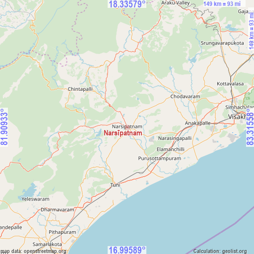
Narsīpatnam GPS coordinates[2]
17° 40' 1.524" North, 82° 36' 44.82" East
| Map corner | latitude | longitude |
|---|---|---|
| Upper-left | 18.33579°, | 81.90933° |
| Center: | 17.66709°, | 82.61245° |
| Lower-right: | 16.99589°, | 83.31558° |
| Map W x H: | 149×149 km | = 92.6×92.6mi |
| max Lat: | 34.9274° ⇑72.6% North |
| Narsīpatnam: | 17.66709° |
| min Lat: | ⇓27.4% South 8.09008° |
| min Long | Narsīpatnam | max Long |
| 68.82655° | 82.61245° | 96.81° |
| W 78.3%⇐ | ⇒21.7% E |
Elevation
Elevation of Narsīpatnam is 85 m = 279 ft, and this is 210.6 m = 691 ft below average elevation for this country.
| Max E: |
3681 m = 12077 ft | 71.8% |
| Avg. | 295.6 m = 970 ft | |
| Narsīpatnam | 85 m = 279 ft | |
Min E: |
1 m = 3 ft | 28.2% |
See also: India elevation on elevation.city.
Geographical zone
Narsīpatnam is located in North Torrid zone (between Equator and Tropic of Cancer). Distance of this Northern Tropic circle is 641.5 km =398.6 mi to North.| Distance of | km | miles | from Narsīpatnam |
|---|---|---|---|
| North Pole | 8042.7 | 4997.5 | to North |
| Arctic Circle | 5436.8 | 3378.3 | to North |
| Tropic Cancer | 641.5 | 398.6 | to North |
| Equator | 1964.4 | 1220.6 | to South |


Nearby cities:
15 places around Narsīpatnam: (largest is in red/bold)
• Akasahebpet
18.7 km =11.6 mi,  195°
195°
• Anakāpalle
41.6 km =25.8 mi,  86°
86°
• Chittarkonda
73.7 km =45.8 mi,  313°
313°
• Chodavaram
38.6 km =24 mi,  62°
62°
• Elamanchili
29.1 km =18.1 mi,  116°
116°
• Etikoppāka
22.6 km =14 mi,  145°
145°
• Gajuwaka
64.1 km =39.8 mi, 86°
• Mādugula
35.1 km =21.8 mi,  37°
37°
• Pithāpuram
72.1 km =44.8 mi,  211°
211°
• Sāmalkot
82.1 km =51 mi, 214°
• Tuni
35 km =21.7 mi,  191°
191°
• Vepagunta
65.1 km =40.5 mi,  79°
79°
• Visakhapatnam
62.4 km =38.8 mi, 88°
• Yārāda
70.1 km =43.6 mi, 90°
• vadlamuru
79.3 km =49.3 mi,  216°
216°
Sources, notices
• [Note1] Compared only with cities in India existing in our database
• [Src1] Map data: © OpenStreetMap contributors (CC-BY-SA)
• [Src2] Other city data from geonames.org with taken over terms of usage.
• [Src3] Geographical zone / Annual Mean Temperature by Robert A. Rohde @ Wikipedia
