Vijayawada geodata
Vijayawada (Andhra Pradesh) is a populated place; located in India in Asia/Kolkata (GMT+5.5) time zone. With population of 874,587 people, there are 50 cities with bigger population in this country. Compared to other cities in India, 76.4% of cities are located further ↑North; 71.5% of cities are located further ←West and 80.2% of cities have higher elevation than Vijayawada. Note1


Vijayawada GPS coordinates[2]
16° 30' 26.82" North, 80° 38' 47.76" East
| Map corner | latitude | longitude |
|---|---|---|
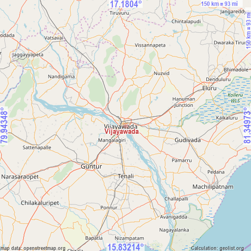
| Upper-left | 17.1804°, | 79.94348° |
| Center: | 16.50745°, | 80.6466° |
| Lower-right: | 15.83214°, | 81.34973° |
| Map W x H: | 149.9×149.9 km | = 93.1×93.1mi |
| max Lat: | 34.9274° ⇑76.4% North |
| Vijayawada: | 16.50745° |
| min Lat: | ⇓23.6% South 8.09008° |
| min Long | Vijayawada | max Long |
| 68.82655° | 80.6466° | 96.81° |
| W 71.5%⇐ | ⇒28.5% E |
Elevation
Elevation of Vijayawada is 47 m = 154 ft, and this is 248.6 m = 816 ft below average elevation for this country.
| Max E: |
3681 m = 12077 ft | 80.2% |
| Avg. | 295.6 m = 970 ft | |
| Vijayawada | 47 m = 154 ft | |
Min E: |
1 m = 3 ft | 19.8% |
See also: Vijayawada elevation on elevation.city.
Geographical zone
Vijayawada is located in North Torrid zone (between Equator and Tropic of Cancer). Distance of this Northern Tropic circle is 770.5 km =478.8 mi to North.| Distance of | km | miles | from Vijayawada |
|---|---|---|---|
| North Pole | 8171.6 | 5077.6 | to North |
| Arctic Circle | 5565.7 | 3458.4 | to North |
| Tropic Cancer | 770.5 | 478.8 | to North |
| Equator | 1835.5 | 1140.5 | to South |


Nearby cities:
15 places around Vijayawada: (largest is in red/bold)
• Bhattiprolu
47.2 km =29.3 mi,  162°
162°
• Gannavaram
17 km =10.6 mi,  77°
77°
• Gudivāda
38.1 km =23.7 mi,  102°
102°
• Gudlavalleru
46.4 km =28.8 mi,  112°
112°
• Guntur
30.7 km =19.1 mi,  221°
221°
• Kankipādu
15.2 km =9.4 mi,  121°
121°
• Kolanukonda
7.1 km =4.4 mi,  212°
212°
• Kondapalle
16.7 km =10.4 mi,  318°
318°
• Mangalagiri
11.9 km =7.4 mi, 224°
• Nandigāma
48.4 km =30.1 mi,  307°
307°
• Nūzvīd
37.8 km =23.5 mi,  34°
34°
• Phirangipuram
47.5 km =29.5 mi,  239°
239°
• Tādepalle
5.6 km =3.5 mi, 241°
• Vuyyūru
26.5 km =16.5 mi,  127°
127°
• Yanamalakuduru
3.3 km =2.1 mi,  137°
137°
Sources, notices
• [Note1] Compared only with cities in India existing in our database
• [Src1] Map data: © OpenStreetMap contributors (CC-BY-SA)
• [Src2] Other city data from geonames.org with taken over terms of usage.
• [Src3] Geographical zone / Annual Mean Temperature by Robert A. Rohde @ Wikipedia
