Nandigāma geodata
Nandigāma (Andhra Pradesh) is a populated place; located in India in Asia/Kolkata (GMT+5.5) time zone. With population of 38,219 people, there are 1149 cities with bigger population in this country. Compared to other cities in India, 75.4% of cities are located further ↑North; 70.3% of cities are located further ←West and 78.3% of cities have higher elevation than Nandigāma. Note1


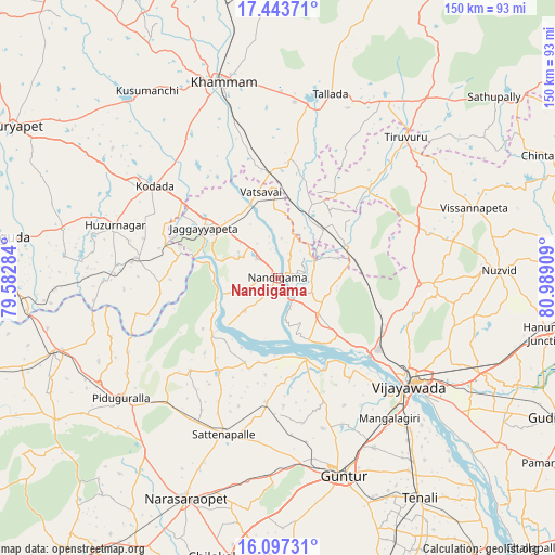
Nandigāma GPS coordinates[2]
16° 46' 18.12" North, 80° 17' 9.456" East
| Map corner | latitude | longitude |
|---|---|---|
| Upper-left | 17.44371°, | 79.58284° |
| Center: | 16.7717°, | 80.28596° |
| Lower-right: | 16.09731°, | 80.98909° |
| Map W x H: | 149.7×149.7 km | = 93×93mi |
| max Lat: | 34.9274° ⇑75.4% North |
| Nandigāma: | 16.7717° |
| min Lat: | ⇓24.6% South 8.09008° |
| min Long | Nandigāma | max Long |
| 68.82655° | 80.28596° | 96.81° |
| W 70.3%⇐ | ⇒29.7% E |
Elevation
Elevation of Nandigāma is 54 m = 177 ft, and this is 241.6 m = 793 ft below average elevation for this country.
| Max E: |
3681 m = 12077 ft | 78.3% |
| Avg. | 295.6 m = 970 ft | |
| Nandigāma | 54 m = 177 ft | |
Min E: |
1 m = 3 ft | 21.7% |
See also: India elevation on elevation.city.
Geographical zone
Nandigāma is located in North Torrid zone (between Equator and Tropic of Cancer). Distance of this Northern Tropic circle is 741.1 km =460.5 mi to North.| Distance of | km | miles | from Nandigāma |
|---|---|---|---|
| North Pole | 8142.2 | 5059.3 | to North |
| Arctic Circle | 5536.3 | 3440.1 | to North |
| Tropic Cancer | 741.1 | 460.5 | to North |
| Equator | 1864.8 | 1158.7 | to South |


Nearby cities:
15 places around Nandigāma: (largest is in red/bold)
• Gannavaram
60.7 km =37.7 mi,  115°
115°
• Guntur
55.6 km =34.5 mi,  160°
160°
• Jaggayyapeta
24.2 km =15 mi,  304°
304°
• Kankipādu
63.5 km =39.5 mi,  126°
126°
• Khammam
55 km =34.2 mi,  344°
344°
• Kodār
42.4 km =26.3 mi,  306°
306°
• Kolanukonda
49.4 km =30.7 mi,  135°
135°
• Kondapalle
32.1 km =19.9 mi, 121°
• Mangalagiri
48.4 km =30.1 mi, 141°
• Nūzvīd
59.6 km =37 mi,  88°
88°
• Phirangipuram
53.5 km =33.2 mi,  182°
182°
• Sattenapalle
44.4 km =27.6 mi,  198°
198°
• Tādepalle
46.3 km =28.8 mi, 133°
• Vijayawada
48.4 km =30.1 mi, 127°
• Yanamalakuduru
51.6 km =32.1 mi, 128°
Sources, notices
• [Note1] Compared only with cities in India existing in our database
• [Src1] Map data: © OpenStreetMap contributors (CC-BY-SA)
• [Src2] Other city data from geonames.org with taken over terms of usage.
• [Src3] Geographical zone / Annual Mean Temperature by Robert A. Rohde @ Wikipedia
